IMAGES TAKEN NEAR TO
Hill Road, PINNER, HA5 1JZ
Introduction
This page details the photographs taken nearby to Hill Road, HA5 1JZ by members of the Geograph project.
The Geograph project started in 2005 with the aim of publishing, organising and preserving representative images for every square kilometre of Great Britain, Ireland and the Isle of Man.

There are currently over 7.5m images from over14,400 individuals and you can help contribute to the project by visiting https://www.geograph.org.uk
Image Map
Images are licensed for reuse under creativecommons.org/licenses/by-sa/2.0
Notes
- Clicking on the map will re-center to the selected point.
- The higher the marker number, the further away the image location is from the centre of the postcode.
Image Listing (39 Images Found)
Images are licensed for reuse under creativecommons.org/licenses/by-sa/2.0
Image
Details
Distance
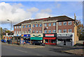
1
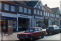
Shops in Cannon Lane, Pinner
Parade of shops in Cannon Lane: Post Office, Hardware store, Newsagent, etc.
Image: © Carl Grove
Taken: 20 Feb 1989
0.05 miles
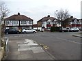
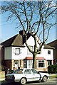
2
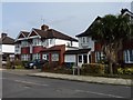
Houses on the east side of Hill Road
Just north of the junction with St Ursula Grove.
Image: © Christine Johnstone
Taken: 8 Mar 2016
0.05 miles
3
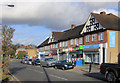
Cannon Lane, Pinner
A terrace of local shops with a couple of decorative gables.
Image: © Des Blenkinsopp
Taken: 13 Nov 2018
0.05 miles
4

Shops in Cannon Lane
Parade of shops, including the post office, newsagent, old-fashioned hardware store (since closed), Chinese take-away and Wine Merchants. At the crossroads with Whittington Way and Lyncroft Avenue.
Image: © Carl Grove
Taken: 20 Feb 1989
0.06 miles
5
Whittington Way at the junction of Cannon Lane
Image: © David Howard
Taken: 21 Jan 2021
0.07 miles
6
Houses on the east side of Cannon Lane
At the junction with St Ursula Grove.
Image: © Christine Johnstone
Taken: 8 Mar 2016
0.08 miles
7
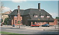
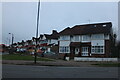
The Whittington, Pinner
The Whittington, since renamed Pinner Arms, was a large pub in Whittington Way.
Image: © Carl Grove
Taken: 28 Apr 1989
0.09 miles
8
Coronation Parade
A bit weatherbeaten but still there, the name is above the central shop.
Image: © Des Blenkinsopp
Taken: 13 Nov 2018
0.10 miles
9
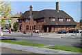
The Whittington public house
The Whittington, standing on Whittington Way (since renamed The Pinner Arms). The road, originally planned as a by-pass, connects Pinner with Rayners Lane.
Image: © Carl Grove
Taken: 3 May 1989
0.11 miles
10
House in Lyncroft Avenue
Suburban heaven: typical 1930s house in Lyncroft Avenue, Pinner.
Image: © Carl Grove
Taken: 16 Feb 1990
0.11 miles