IMAGES TAKEN NEAR TO
West End Lane, PINNER, HA5 1EE
Introduction
This page details the photographs taken nearby to West End Lane, HA5 1EE by members of the Geograph project.
The Geograph project started in 2005 with the aim of publishing, organising and preserving representative images for every square kilometre of Great Britain, Ireland and the Isle of Man.

There are currently over 7.5m images from over14,400 individuals and you can help contribute to the project by visiting https://www.geograph.org.uk
Image Map
Images are licensed for reuse under creativecommons.org/licenses/by-sa/2.0
Notes
- Clicking on the map will re-center to the selected point.
- The higher the marker number, the further away the image location is from the centre of the postcode.
Image Listing (44 Images Found)
Images are licensed for reuse under creativecommons.org/licenses/by-sa/2.0
Image
Details
Distance
1
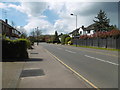
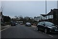
West End Lane, Pinner
The River Pinn runs behind the houses on the left. The Pinn is a tributary of the Frays River which it joins at Yiewsley after passing through Ickenham and Uxbridge.
Image: © Marathon
Taken: 27 Apr 2016
0.02 miles
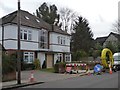
2
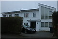
House on Meadow Road, Pinner
This is a very ordinary house with a very fancy extension.
Image: © David Howard
Taken: 21 Jan 2021
0.05 miles
3

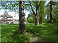
Between West End Lane and the River Pinn
This small green space is found between the River Pinn on the right and the back gardens of West End Lane on the left.
The Pinn is a tributary of the Frays River which it joins at Yiewsley after passing through Ickenham and Uxbridge.
Image: © Marathon
Taken: 27 Apr 2016
0.06 miles
4
Green next to the River Pinn
This small green space is found between the River Pinn on the right and the back gardens of West End Lane on the left.
The Pinn is a tributary of the Frays River which it joins at Yiewsley after passing through Ickenham and Uxbridge. Pinner, of course, takes its name from the river.
Image: © Marathon
Taken: 27 Apr 2016
0.06 miles
5
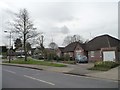
Bungalows on West End Lane, Pinner
On the west side, near the junction with Cranbourne Drive.
Image: © Christine Johnstone
Taken: 8 Mar 2016
0.06 miles
7
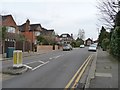
West End Avenue, Pinner
Running east from West End Lane.
Image: © Christine Johnstone
Taken: 8 Mar 2016
0.06 miles
8
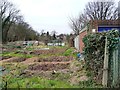
Cuckoo Hill allotments, Pinner
With 34 plots. Off Cranbourne Drive.
Image: © Christine Johnstone
Taken: 8 Mar 2016
0.07 miles
9
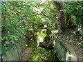
River Pinn
Just below the Eastcote Road bridge.
Image: © Robin Webster
Taken: 29 Sep 2012
0.07 miles
10
Laying gas pipeline in Cranbourne Drive
The pavement on the south side is temporarily closed. Why do they call it a 'footway'?
Image: © Christine Johnstone
Taken: 8 Mar 2016
0.08 miles