IMAGES TAKEN NEAR TO
Crest View, PINNER, HA5 1AN
Introduction
This page details the photographs taken nearby to Crest View, HA5 1AN by members of the Geograph project.
The Geograph project started in 2005 with the aim of publishing, organising and preserving representative images for every square kilometre of Great Britain, Ireland and the Isle of Man.

There are currently over 7.5m images from over14,400 individuals and you can help contribute to the project by visiting https://www.geograph.org.uk
Image Map
Images are licensed for reuse under creativecommons.org/licenses/by-sa/2.0
Notes
- Clicking on the map will re-center to the selected point.
- The higher the marker number, the further away the image location is from the centre of the postcode.
Image Listing (33 Images Found)
Images are licensed for reuse under creativecommons.org/licenses/by-sa/2.0
Image
Details
Distance
1
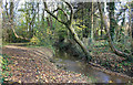
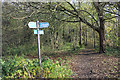
Celandine Route and River Pinn
The Celandine Route follows the River Pinn between Pinner and Uxbridge.
Not always as closely as this though. A particularly nice section of the route through woodland.
Image: © Des Blenkinsopp
Taken: 13 Nov 2018
0.12 miles
2
Detached houses, West End Lane, Pinner
On the west side of the road, just south of Hillcrest Avenue.
Image: © Christine Johnstone
Taken: 8 Mar 2016
0.15 miles
3
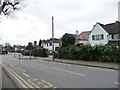
Traffic calming chicane, West End Lane
South of the school.
Image: © Christine Johnstone
Taken: 8 Mar 2016
0.16 miles
4
Celandine Way
Footpath beside the River Pinn.
Image: © Marion Phillips
Taken: 3 Jun 2011
0.18 miles
5
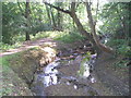
The Celandine Route in the Woods
The Celandine Route runs for twelve miles or so between Pinner and Uxbridge following the River Pinn. This section is especially pleasant with the river flowing through a long corridor of woodland quite secluded from the housing which is only a short distance away.
Image: © Des Blenkinsopp
Taken: 13 Nov 2018
0.18 miles
6
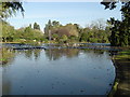
Pinner Memorial Park: The Pond
1,189 birds cannot be wrong. Despite being partially frozen over, the pond with its fountain must be the place to be! Pinner Memorial Park is said to cover 13 acres, or 5 hectares, in this grid square and TQ1289.
Image: © Nigel Cox
Taken: 20 Nov 2005
0.18 miles
7
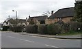
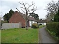
1, 2, 3 West House Cottages, Pinner
Off the east side of West End Lane, backing onto Pinner Memorial Park.
Image: © Christine Johnstone
Taken: 8 Mar 2016
0.18 miles
8
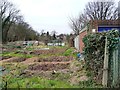
Cuckoo Hill allotments, Pinner
With 34 plots. Off Cranbourne Drive.
Image: © Christine Johnstone
Taken: 8 Mar 2016
0.19 miles
9
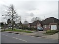
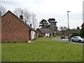
Bungalows on West End Lane, Pinner
On the west side, near the junction with Cranbourne Drive.
Image: © Christine Johnstone
Taken: 8 Mar 2016
0.19 miles
10
Bungalows on Dickson Fold, Pinner
On the east side of West End Lane.
Image: © Christine Johnstone
Taken: 8 Mar 2016
0.19 miles