IMAGES TAKEN NEAR TO
Woodlands Avenue, RUISLIP, HA4 9RQ
Introduction
This page details the photographs taken nearby to Woodlands Avenue, HA4 9RQ by members of the Geograph project.
The Geograph project started in 2005 with the aim of publishing, organising and preserving representative images for every square kilometre of Great Britain, Ireland and the Isle of Man.

There are currently over 7.5m images from over14,400 individuals and you can help contribute to the project by visiting https://www.geograph.org.uk
Image Map
Images are licensed for reuse under creativecommons.org/licenses/by-sa/2.0
Notes
- Clicking on the map will re-center to the selected point.
- The higher the marker number, the further away the image location is from the centre of the postcode.
Image Listing (16 Images Found)
Images are licensed for reuse under creativecommons.org/licenses/by-sa/2.0
Image
Details
Distance
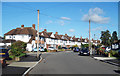

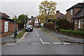
4
Roundabout at Eastcote
This is between Roxbourne Park and Eastcote station. Beyond the roundabout Cardinal Road is to the left and Cranmer Close to the right. A fan of the Tudors must have come up with the names of the roads on this estate as there is also Aragon Drive, Boleyn Drive, Cleves Way and Essex Close.
Image: © Marathon
Taken: 13 Apr 2016
0.20 miles
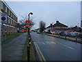
6
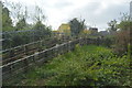
Electrical cables by the Metropolitan Line
Image: © N Chadwick
Taken: 12 Apr 2017
0.23 miles
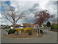
7
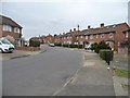
Castleton Road, Eastcote, looking northwards
From the footpath to Roxbourne Park.
Image: © Christine Johnstone
Taken: 8 Mar 2016
0.23 miles
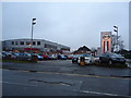
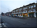
10
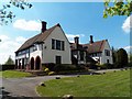
Cavendish Pavilion
Front of the Cavendish Pavilion, now known as The Cavendish, facing Field End Road.
Image: © Ian Harrison
Taken: 6 May 2013
0.23 miles