IMAGES TAKEN NEAR TO
Cardinal Road, RUISLIP, HA4 9PY
Introduction
This page details the photographs taken nearby to Cardinal Road, HA4 9PY by members of the Geograph project.
The Geograph project started in 2005 with the aim of publishing, organising and preserving representative images for every square kilometre of Great Britain, Ireland and the Isle of Man.

There are currently over 7.5m images from over14,400 individuals and you can help contribute to the project by visiting https://www.geograph.org.uk
Image Map (Loading...)


Getting Data...Please wait
Leaflet Map data © OpenStreetMap
Images are licensed for reuse under creativecommons.org/licenses/by-sa/2.0
Notes
- Clicking on the map will re-center to the selected point.
- The higher the marker number, the further away the image location is from the centre of the postcode.
Image Listing (17 Images Found)
Images are licensed for reuse under creativecommons.org/licenses/by-sa/2.0
Image
Details
Distance
1
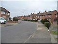
Castleton Road, Eastcote, looking northwards
From the footpath to Roxbourne Park.
Image: © Christine Johnstone
Taken: 8 Mar 2016
0.11 miles
2
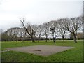
Basketball hoop, Roxbourn Park
The rest of this area is just grassy open space, crossed by a line of trees.
Image: © Christine Johnstone
Taken: 8 Mar 2016
0.13 miles
3
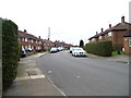
Castleton Road, Eastcote, looking westwards
From the footpath to Roxbourne Park.
Image: © Christine Johnstone
Taken: 8 Mar 2016
0.15 miles
4
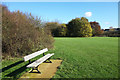
Bench in Roxbourne Park
Roxbourne Park is 26 hectares of grass, woods and sports fields beside the Roxbourne at the top of the Yeading Brook in the Crane catchment.
Image: © Des Blenkinsopp
Taken: 27 Oct 2017
0.15 miles
5
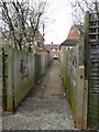
Footpath to Castleton Road from Roxbourne Park
Passing north-westwards between two back gardens.
Image: © Christine Johnstone
Taken: 8 Mar 2016
0.15 miles
6
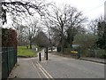
Cannon Lane changes from a road to a track / path
As it enters Roxbourne Park from the north.
Image: © Christine Johnstone
Taken: 8 Mar 2016
0.16 miles
8
Roxbourne Park
Roxbourne Park is located either side of The Roxbourne river. The Roxbourne is also known as the western arm of the Yeading Brook. It rises near North Harrow and converges with the Yeading Brook in Ruislip on the southern side of Western Avenue. This in turn flows into the River Crane which reaches the Thames at Isleworth. See http://www.londonslostrivers.com/yeading-brook.html for more information and photographs of the Roxbourne.
The other notable feature of Roxbourne Park is the miniature railway which has been here since 1976. See http://www.hwsme.org/ for details of the railway and https://www.youtube.com/watch?v=XpEX4E5GMPk for videos of the trains in action.
Image: © Marathon
Taken: 13 Apr 2016
0.18 miles
9
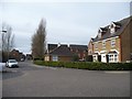
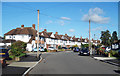
New housing development, Stirling Avenue
On the west side of Cannon Lane. In March 2016 a five bedroomed house is on sale here for £799,950.
Image: © Christine Johnstone
Taken: 8 Mar 2016
0.18 miles
10
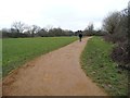
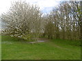
Heading south-west on public footpath R170
In Roxbourne Park, near Yeading Brook.
Image: © Christine Johnstone
Taken: 8 Mar 2016
0.19 miles