IMAGES TAKEN NEAR TO
Elliott Avenue, RUISLIP, HA4 9LZ
Introduction
This page details the photographs taken nearby to Elliott Avenue, HA4 9LZ by members of the Geograph project.
The Geograph project started in 2005 with the aim of publishing, organising and preserving representative images for every square kilometre of Great Britain, Ireland and the Isle of Man.

There are currently over 7.5m images from over14,400 individuals and you can help contribute to the project by visiting https://www.geograph.org.uk
Image Map
Images are licensed for reuse under creativecommons.org/licenses/by-sa/2.0
Notes
- Clicking on the map will re-center to the selected point.
- The higher the marker number, the further away the image location is from the centre of the postcode.
Image Listing (5 Images Found)
Images are licensed for reuse under creativecommons.org/licenses/by-sa/2.0
Image
Details
Distance
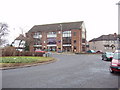
1
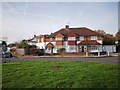
Semi-detached Houses on Steroids
Both sides of this 1950's semi have two storey extensions with the right side managing to fit in a traditional garage.
32% of UK housing was semi-detached in 2008. The trend is on the decline now.
More info : https://en.wikipedia.org/wiki/Semi-detached
Image: © James Emmans
Taken: 20 Nov 2019
0.20 miles
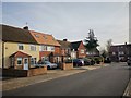
3
Ruislip Manor shops
These are at the junction of Chelston Road and Victoria Road. There are more shops further north on Victoria Road.
Image: © David Hawgood
Taken: 3 Jan 2006
0.24 miles
4
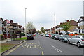
Bus stop and shelter on Victoria Road, Ruislip
Looking north west.
Image: © JThomas
Taken: 13 Apr 2019
0.24 miles
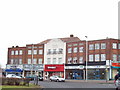
5
Ruislip Manor Library
At the junction of Chelston Road and Victoria Road
Image: © David Hawgood
Taken: 3 Jan 2006
0.24 miles