IMAGES TAKEN NEAR TO
Whitby Road, RUISLIP, HA4 9ED
Introduction
This page details the photographs taken nearby to Whitby Road, HA4 9ED by members of the Geograph project.
The Geograph project started in 2005 with the aim of publishing, organising and preserving representative images for every square kilometre of Great Britain, Ireland and the Isle of Man.

There are currently over 7.5m images from over14,400 individuals and you can help contribute to the project by visiting https://www.geograph.org.uk
Image Map
Images are licensed for reuse under creativecommons.org/licenses/by-sa/2.0
Notes
- Clicking on the map will re-center to the selected point.
- The higher the marker number, the further away the image location is from the centre of the postcode.
Image Listing (35 Images Found)
Images are licensed for reuse under creativecommons.org/licenses/by-sa/2.0
Image
Details
Distance
1
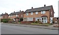
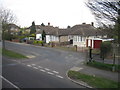
Houses on the north side of Whitby Road
The housing along this street is a mixture of semi-detached houses and low blocks of four flats.
Image: © Christine Johnstone
Taken: 8 Mar 2016
0.06 miles
2
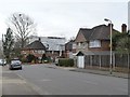
Raising the roof on Oxford Drive
Probably another loft conversion.
Image: © Christine Johnstone
Taken: 8 Mar 2016
0.07 miles
3
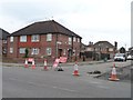
Collins Drive, closed for resurfacing
On the north side of Whitby Road.
Image: © Christine Johnstone
Taken: 8 Mar 2016
0.08 miles
4
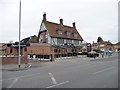
Venue 5, Field End Road
A restaurant and banqueting suite serving Indian and Indian-Chinese fusion food. Here since 2003. The building was formerly the Clay Pigeon pub.
Image: © Christine Johnstone
Taken: 8 Mar 2016
0.08 miles
5
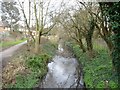
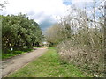
Yeading Brook
Looking north-east [upstream] from the public footpath footbridge.
Image: © Christine Johnstone
Taken: 8 Mar 2016
0.09 miles
6
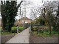
Footbridge over Yeading Brook
Carrying the public footpath from Mount Pleasant to St Andrew's Close.
Image: © Christine Johnstone
Taken: 8 Mar 2016
0.09 miles
8
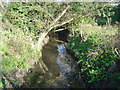
Yeading Brook, Eastcote
Viewed looking upstream from the Field End Road bridge.
Image: © Nigel Cox
Taken: 20 Nov 2005
0.10 miles
9
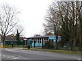
The Tudor Club, Field End Road, Eastcote
The Tudor Club is a members-only luncheon club for the over 60's. It is a charity and provides healthy 3-course home-cooked lunches every weekday.
Image: © Christine Johnstone
Taken: 8 Mar 2016
0.10 miles
10
Near the entrance to Roxbourne Park
Roxbourne Park is located either side of The Roxbourne river. The Roxbourne is also known as the western arm of the Yeading Brook. It rises near North Harrow and converges with the Yeading Brook in Ruislip on the southern side of Western Avenue. This in turn flows into the River Crane which reaches the Thames at Isleworth. See http://www.londonslostrivers.com/yeading-brook.html for more information and photographs of the Roxbourne.
The other notable feature of Roxbourne Park is the miniature railway which has been here since 1976. See http://www.hwsme.org/ for details of the railway and https://www.youtube.com/watch?v=XpEX4E5GMPk for videos of the trains in action.
This is near the entrance to the park from Field End Road.
Image: © Marathon
Taken: 13 Apr 2016
0.13 miles