IMAGES TAKEN NEAR TO
Pembroke Road, RUISLIP, HA4 8NW
Introduction
This page details the photographs taken nearby to Pembroke Road, HA4 8NW by members of the Geograph project.
The Geograph project started in 2005 with the aim of publishing, organising and preserving representative images for every square kilometre of Great Britain, Ireland and the Isle of Man.

There are currently over 7.5m images from over14,400 individuals and you can help contribute to the project by visiting https://www.geograph.org.uk
Image Map
Images are licensed for reuse under creativecommons.org/licenses/by-sa/2.0
Notes
- Clicking on the map will re-center to the selected point.
- The higher the marker number, the further away the image location is from the centre of the postcode.
Image Listing (87 Images Found)
Images are licensed for reuse under creativecommons.org/licenses/by-sa/2.0
Image
Details
Distance
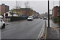
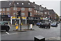
1
JJ Moon's public house, Ruislip Manor
Image: © Stacey Harris
Taken: 30 Dec 2010
0.02 miles
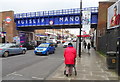
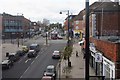
3
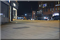
London Borough of Hillingdon : Pembroke Road
A pavement between Pembroke Road and Victoria Road.
Image: © Lewis Clarke
Taken: 23 Mar 2018
0.02 miles
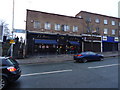
4
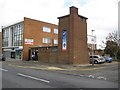
Ruislip: Former World War II gas de-contamination building
The stranger strolling by along Pembroke Road might casually glance at this structure and quickly dismiss it as a public convenience, or other municipal or utility building. However it has far more sinister origins and is so unusual that it merits Grade II listing status.
The English Heritage listed buildings web page describes it thus:
"Gas de-contamination centre, later church hall. Built in 1941 by Ruislip and Northwood Urban District Council to counter the expected gas warfare on civilians. The style is derived from Dudok.
Exterior description:-
Built of reinforced concrete clad in wirecut bricks in English bond with metal-framed casements and flat roof. L-shaped in plan. Mainly one storey but two storey tower to west. North front has four narrow single metal-framed casements and triple casement to right with projecting brick stringcourse underneath. Brickwork around the windows shows signs of fixing for external shutters. Flush door with rectangular fanlight with frosted glass and later low disabled access ramp. Projecting two storey west tower (boiler room and water tank) has tall window (currently concealed by the banner) on north face with flat semi-circular shaped concrete lintel above. East side has two casements at the top and west side has one window at the top. Corner chimney projects and has three recessed channels. Separate access to tower on south side. East and west sides have five triple metal casements and brick projecting stringcourse below windows. South end has two separate entrances.
Interior description:-
North part has toilets on either side of door, small room on east side, larger room to west with triangular shelf and double wall opposite probably acting as an airlock with two cupboards with shelves for clothing. There is a long room with three concrete roof girders which leads into two separately accessed rooms at the south end each with outside access. The long room probably had partitions originally. Wooden parquet floor probably added later. Layout of the gas de-contamination centre would have included an undressing area, eye douche and showers, drying rooms and dressing rooms."
One wonders now just how such a small facility would be expected to cater for a sudden influx of a large number, maybe hundreds or even thousands, of distressed victims of such an attack, coming from all the surrounding areas.
Today the building is called the Windmill Hall, and appears to be available for functions.
Image: © Nigel Cox
Taken: 16 May 2010
0.03 miles
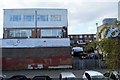
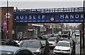
7
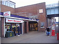
Ruislip Manor Tube station, north entrance
Image: © David Howard
Taken: 16 Jan 2009
0.03 miles