IMAGES TAKEN NEAR TO
Pembroke Road, RUISLIP, HA4 8NE
Introduction
This page details the photographs taken nearby to Pembroke Road, HA4 8NE by members of the Geograph project.
The Geograph project started in 2005 with the aim of publishing, organising and preserving representative images for every square kilometre of Great Britain, Ireland and the Isle of Man.

There are currently over 7.5m images from over14,400 individuals and you can help contribute to the project by visiting https://www.geograph.org.uk
Image Map (Loading...)


Getting Data...Please wait
Leaflet Map data © OpenStreetMap
Images are licensed for reuse under creativecommons.org/licenses/by-sa/2.0
Notes
- Clicking on the map will re-center to the selected point.
- The higher the marker number, the further away the image location is from the centre of the postcode.
Image Listing (118 Images Found)
Images are licensed for reuse under creativecommons.org/licenses/by-sa/2.0
Image
Details
Distance
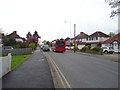
5
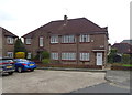
Parkway Court, Ruislip
Houses off Pembroke Road.
Image: © JThomas
Taken: 13 Apr 2019
0.06 miles
6

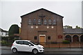
Roman Catholic Church of the Most Sacred Heart, Ruislip
Image: © JThomas
Taken: 13 Apr 2019
0.08 miles
8
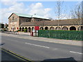
Ruislip - Catholic church on Pembroke Road
Image: © Peter Whatley
Taken: 2 Apr 2012
0.08 miles
9
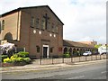
Ruislip: Roman Catholic Church of the Most Sacred Heart
The church was built in 1938 and is at 73 Pembroke Road. It has a most comprehensive website here http://www.mostsacredheartruislip.co.uk/
Image: © Nigel Cox
Taken: 16 May 2010
0.08 miles