IMAGES TAKEN NEAR TO
Eastcote Road, RUISLIP, HA4 8DH
Introduction
This page details the photographs taken nearby to Eastcote Road, HA4 8DH by members of the Geograph project.
The Geograph project started in 2005 with the aim of publishing, organising and preserving representative images for every square kilometre of Great Britain, Ireland and the Isle of Man.

There are currently over 7.5m images from over14,400 individuals and you can help contribute to the project by visiting https://www.geograph.org.uk
Image Map
Images are licensed for reuse under creativecommons.org/licenses/by-sa/2.0
Notes
- Clicking on the map will re-center to the selected point.
- The higher the marker number, the further away the image location is from the centre of the postcode.
Image Listing (54 Images Found)
Images are licensed for reuse under creativecommons.org/licenses/by-sa/2.0
Image
Details
Distance
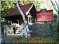
1
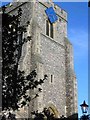
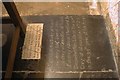
C of E Church in Ruislip
This churchyard is accessed through an alleyway off the shopping street. Think the saint is St Andrew
Image: © Jack Hill
Taken: 12 Jul 2005
0.13 miles
2
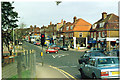
The Centre of Ruislip.
A pleasant town, on the outer edges of London's suburbia.
Image: © Ron Hann
Taken: Unknown
0.13 miles
4
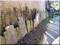
Entrance gate to St Martins
This is side entrance to Grave yard at rear of church.
Image: © pearl gardner
Taken: 6 Nov 2006
0.13 miles