IMAGES TAKEN NEAR TO
Wallington Close, RUISLIP, HA4 7YJ
Introduction
This page details the photographs taken nearby to Wallington Close, HA4 7YJ by members of the Geograph project.
The Geograph project started in 2005 with the aim of publishing, organising and preserving representative images for every square kilometre of Great Britain, Ireland and the Isle of Man.

There are currently over 7.5m images from over14,400 individuals and you can help contribute to the project by visiting https://www.geograph.org.uk
Image Map
Images are licensed for reuse under creativecommons.org/licenses/by-sa/2.0
Notes
- Clicking on the map will re-center to the selected point.
- The higher the marker number, the further away the image location is from the centre of the postcode.
Image Listing (18 Images Found)
Images are licensed for reuse under creativecommons.org/licenses/by-sa/2.0
Image
Details
Distance
4
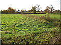
Newyears Green: Mad Bess Brook
Mad Bess Brook is a tributary of the River Pinn and is seen here heading from Fine Bush Lane towards Breakspear Road and the northern outskirts of Ruislip.
Image: © Nigel Cox
Taken: 7 Nov 2008
0.17 miles
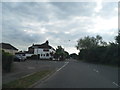
5
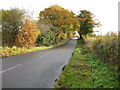
Newyears Green: Fine Bush Lane
The low point in the road is where Mad Bess Brook passes under.
Image: © Nigel Cox
Taken: 7 Nov 2008
0.18 miles
10
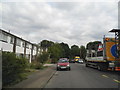
Breakspear Crematorium
Breakspear Crematorium, Breakspear Road, Ruislip
Image: © Russell Trebor
Taken: 7 Jan 2007
0.23 miles