IMAGES TAKEN NEAR TO
Broadwood Avenue, RUISLIP, HA4 7XS
Introduction
This page details the photographs taken nearby to Broadwood Avenue, HA4 7XS by members of the Geograph project.
The Geograph project started in 2005 with the aim of publishing, organising and preserving representative images for every square kilometre of Great Britain, Ireland and the Isle of Man.

There are currently over 7.5m images from over14,400 individuals and you can help contribute to the project by visiting https://www.geograph.org.uk
Image Map
Images are licensed for reuse under creativecommons.org/licenses/by-sa/2.0
Notes
- Clicking on the map will re-center to the selected point.
- The higher the marker number, the further away the image location is from the centre of the postcode.
Image Listing (12 Images Found)
Images are licensed for reuse under creativecommons.org/licenses/by-sa/2.0
Image
Details
Distance
2
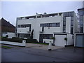
Houses on Park Avenue Ruislip
These houses date from 1936, and were designed by Connell, Ward and Lucas, described as "pioneer modernists" by Pevsner and Cherry in the Buildings of Britain (London 3: Northwest, published 1991).
Image: © David Howard
Taken: 16 Jan 2009
0.06 miles
3
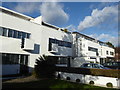
Typical 1930s houses in Park Avenue, Ruislip
The clean straight lines can only be from the Art Deco period of the 1930s. Another example can be seen at https://www.geograph.org.uk/photo/3923094
Image: © Marathon
Taken: 31 Jan 2018
0.09 miles
4
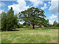
A stately oak
In the field behind St Martin's Approach.
Image: © Robin Webster
Taken: 31 Aug 2014
0.14 miles
5
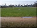
Kings College Playing Field
Kings College Playing Field track and football pitch
Image: © Shaun Ferguson
Taken: 24 Mar 2010
0.14 miles
7
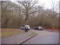
Park Wood entrance, Ruislip
From King's College Road.
Image: © David Howard
Taken: 16 Jan 2009
0.17 miles
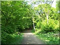
8
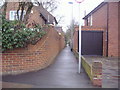
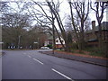
Ruislip - Sherwood Avenue junction with Broadwood Avenue
Footpath entrance to Ruislip Woods National Nature Reserve.
Wood info : https://en.wikipedia.org/wiki/Ruislip_Woods
Image: © James Emmans
Taken: 4 Aug 2019
0.17 miles
10
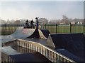
Skateboard Park
Situated just south of the running track beside the River Pinn.
Image: © David Squire
Taken: 11 Dec 2005
0.21 miles