IMAGES TAKEN NEAR TO
Sandalwood Drive, RUISLIP, HA4 7JT
Introduction
This page details the photographs taken nearby to Sandalwood Drive, HA4 7JT by members of the Geograph project.
The Geograph project started in 2005 with the aim of publishing, organising and preserving representative images for every square kilometre of Great Britain, Ireland and the Isle of Man.

There are currently over 7.5m images from over14,400 individuals and you can help contribute to the project by visiting https://www.geograph.org.uk
Image Map
Images are licensed for reuse under creativecommons.org/licenses/by-sa/2.0
Notes
- Clicking on the map will re-center to the selected point.
- The higher the marker number, the further away the image location is from the centre of the postcode.
Image Listing (6 Images Found)
Images are licensed for reuse under creativecommons.org/licenses/by-sa/2.0
Image
Details
Distance
4
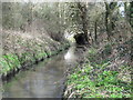
The River Pinn near Woodville Gardens, HA4
Image: © Mike Quinn
Taken: 2 Mar 2016
0.22 miles
5
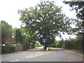
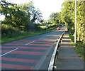
Ruislip: Glovers Grove
Two old oak trees (there is another behind the one in view) demand that the road passes either side of them with a short section of dual carriageway at the top end of Glovers Grove at its junction with Breakspear Road.
Image: © Nigel Cox
Taken: 6 Oct 2007
0.23 miles