IMAGES TAKEN NEAR TO
Barnwood Close, RUISLIP, HA4 7HE
Introduction
This page details the photographs taken nearby to Barnwood Close, HA4 7HE by members of the Geograph project.
The Geograph project started in 2005 with the aim of publishing, organising and preserving representative images for every square kilometre of Great Britain, Ireland and the Isle of Man.

There are currently over 7.5m images from over14,400 individuals and you can help contribute to the project by visiting https://www.geograph.org.uk
Image Map (Loading...)


Getting Data...Please wait
Leaflet Map data © OpenStreetMap
Images are licensed for reuse under creativecommons.org/licenses/by-sa/2.0
Notes
- Clicking on the map will re-center to the selected point.
- The higher the marker number, the further away the image location is from the centre of the postcode.
Image Listing (121 Images Found)
Images are licensed for reuse under creativecommons.org/licenses/by-sa/2.0
Image
Details
Distance
6
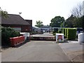
RAF Blenheim Crescent
Military base in West Ruislip
Image: © Ian Harrison
Taken: 24 Apr 2011
0.09 miles
7
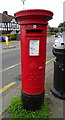
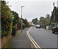
George V postbox on Ickenham Road, Ruislip
Postbox No. HA4 340.
See Image] for context.
Image: © JThomas
Taken: 13 Apr 2019
0.09 miles
8
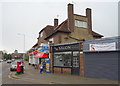
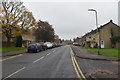
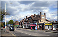
Shops on Ickenham Road, Ruislip
Showing position of Postbox No. HA4 340.
See Image] for postbox.
Image: © JThomas
Taken: 13 Apr 2019
0.09 miles
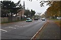
9
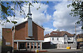
Latter Day Saints, West Ruislip
Mormon Church on Ickenham Road.
Image: © Des Blenkinsopp
Taken: 8 Apr 2014
0.09 miles
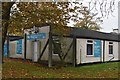
10
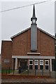
Church of Jesus Christ Latter Day Saints
Image: © N Chadwick
Taken: 3 Nov 2019
0.09 miles