IMAGES TAKEN NEAR TO
Blenheim Crescent, RUISLIP, HA4 7HA
Introduction
This page details the photographs taken nearby to Blenheim Crescent, HA4 7HA by members of the Geograph project.
The Geograph project started in 2005 with the aim of publishing, organising and preserving representative images for every square kilometre of Great Britain, Ireland and the Isle of Man.

There are currently over 7.5m images from over14,400 individuals and you can help contribute to the project by visiting https://www.geograph.org.uk
Image Map (Loading...)


Getting Data...Please wait
Leaflet Map data © OpenStreetMap
Images are licensed for reuse under creativecommons.org/licenses/by-sa/2.0
Notes
- Clicking on the map will re-center to the selected point.
- The higher the marker number, the further away the image location is from the centre of the postcode.
Image Listing (18 Images Found)
Images are licensed for reuse under creativecommons.org/licenses/by-sa/2.0
Image
Details
Distance

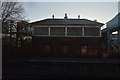
3
RAF Blenheim Crescent
Military base in West Ruislip
Image: © Ian Harrison
Taken: 24 Apr 2011
0.13 miles
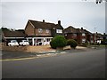
4
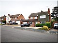
Chichester Avenue
Detached modern houses.
Image: © James Emmans
Taken: 4 Aug 2019
0.15 miles
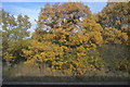
6
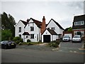
Old Original House in Chichester Avenue
The surround housing was probably built on this house's land.
Image: © James Emmans
Taken: 4 Aug 2019
0.19 miles
7
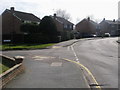
Chichester Avenue
Chichester Avenue passing Poole close
Image: © Shaun Ferguson
Taken: 24 Mar 2010
0.20 miles
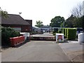
8
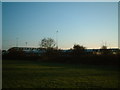
Central Line Depot
Taken from Sports Ground on other side of tracks. See http://www.geograph.org.uk/photo/82406 Photo taken from below bottom right of aerial view.
Image: © Ray Stanton
Taken: 28 Dec 2005
0.21 miles
9
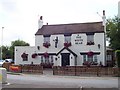
The White Bear
The White Bear
Ruislip
Image: © Russell Trebor
Taken: 11 Jul 2006
0.22 miles