IMAGES TAKEN NEAR TO
Sovereign Close, RUISLIP, HA4 7EF
Introduction
This page details the photographs taken nearby to Sovereign Close, HA4 7EF by members of the Geograph project.
The Geograph project started in 2005 with the aim of publishing, organising and preserving representative images for every square kilometre of Great Britain, Ireland and the Isle of Man.

There are currently over 7.5m images from over14,400 individuals and you can help contribute to the project by visiting https://www.geograph.org.uk
Image Map (Loading...)


Getting Data...Please wait
Leaflet Map data © OpenStreetMap
Images are licensed for reuse under creativecommons.org/licenses/by-sa/2.0
Notes
- Clicking on the map will re-center to the selected point.
- The higher the marker number, the further away the image location is from the centre of the postcode.
Image Listing (97 Images Found)
Images are licensed for reuse under creativecommons.org/licenses/by-sa/2.0
Image
Details
Distance
2
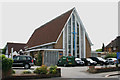
Methodist Church, Ickenham Road, Ruislip
Image: © David Kemp
Taken: 23 Jun 2011
0.06 miles
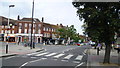
5
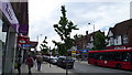
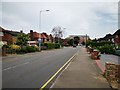
Part of the High Street in Ruislip
A busy high street at this time of day.
Image: © Jeremy Bolwell
Taken: 26 Jun 2014
0.08 miles
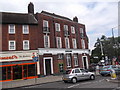
8
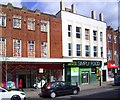
M&S Simply Food
Marks & Spencers have got the centre unit of this typical suburban shop-flat terrace.
Image: © Des Blenkinsopp
Taken: 7 Apr 2014
0.09 miles
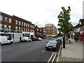
9
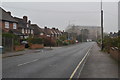
Part of Ruislip high street
A nice, varied and well appointed main street. In my humble opinion.
Image: © Jeremy Bolwell
Taken: 26 Jun 2014
0.10 miles
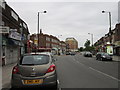
10
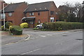
Lloyds Bank, Ickenham Road, Ruislip
At the junction with High Street
Image: © Robin Sones
Taken: 15 Aug 2014
0.10 miles