IMAGES TAKEN NEAR TO
Regency Drive, RUISLIP, HA4 7EE
Introduction
This page details the photographs taken nearby to Regency Drive, HA4 7EE by members of the Geograph project.
The Geograph project started in 2005 with the aim of publishing, organising and preserving representative images for every square kilometre of Great Britain, Ireland and the Isle of Man.

There are currently over 7.5m images from over14,400 individuals and you can help contribute to the project by visiting https://www.geograph.org.uk
Image Map (78 Images)


Getting Data...Please wait
Leaflet Map data © OpenStreetMap
Images are licensed for reuse under creativecommons.org/licenses/by-sa/2.0
Notes
- Clicking on the map will re-center to the selected point.
- The higher the marker number, the further away the image location is from the centre of the postcode.
Image Listing (78 Images Found)
Images are licensed for reuse under creativecommons.org/licenses/by-sa/2.0
Image
Details
Distance
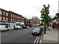
4
Kings End at the junction of High Street Ruislip
Image: © David Howard
Taken: 30 Apr 2015
0.07 miles
7
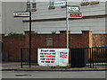
HS2 protest banner, Ruislip
For more on High Speed Two rail network visit this http://www.hs2.org.uk/about-hs2. For the opposition to this controversial plan visit this http://stophs2.org/.
Image: © Jim Osley
Taken: 16 Feb 2013
0.08 miles