IMAGES TAKEN NEAR TO
Ickenham Road, RUISLIP, HA4 7DX
Introduction
This page details the photographs taken nearby to Ickenham Road, HA4 7DX by members of the Geograph project.
The Geograph project started in 2005 with the aim of publishing, organising and preserving representative images for every square kilometre of Great Britain, Ireland and the Isle of Man.

There are currently over 7.5m images from over14,400 individuals and you can help contribute to the project by visiting https://www.geograph.org.uk
Image Map
Images are licensed for reuse under creativecommons.org/licenses/by-sa/2.0
Notes
- Clicking on the map will re-center to the selected point.
- The higher the marker number, the further away the image location is from the centre of the postcode.
Image Listing (132 Images Found)
Images are licensed for reuse under creativecommons.org/licenses/by-sa/2.0
Image
Details
Distance
1
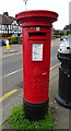
George V postbox on Ickenham Road, Ruislip
Postbox No. HA4 340.
See Image] for context.
Image: © JThomas
Taken: 13 Apr 2019
0.02 miles
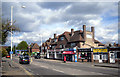
3
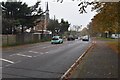
Shops on Ickenham Road, Ruislip
Showing position of Postbox No. HA4 340.
See Image] for postbox.
Image: © JThomas
Taken: 13 Apr 2019
0.03 miles
10

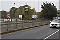
HS2 works, West Ruislip, May 2023 – neighbour
OpenStreetMap labels the site 'HS2 Northolt Tunnels West Portal'. The high speed line, from its Euston terminus, will pass beneath West London in tunnels, emerging here at West Ruislip: see Image The view is roughly northeast from the bridge that carries Ickenham Road over the railway. The building is the clubhouse of Ruislip Golf Club, who may have lost part of their course to HS2. The photo shows the southeastern end of the contractor's extensive site, partly taken up with a large mound of excavated material. It is understood that the tunnel-boring machine (TBM) starts tunnelling at a vertical rock-face. That will have been achieved by digging a large deep pit using conventional earth-moving machines – hence the mound. The TBM is assembled in the pit. The remodelled pit becomes the portal of the tunnel. A similar process was carried out in Warwickshire, see Image
Image reference: 7492236
Image: © Robin Stott
Taken: 20 May 2023
0.09 miles