IMAGES TAKEN NEAR TO
Station Approach, RUISLIP, HA4 6SD
Introduction
This page details the photographs taken nearby to Station Approach, HA4 6SD by members of the Geograph project.
The Geograph project started in 2005 with the aim of publishing, organising and preserving representative images for every square kilometre of Great Britain, Ireland and the Isle of Man.

There are currently over 7.5m images from over14,400 individuals and you can help contribute to the project by visiting https://www.geograph.org.uk
Image Map
Images are licensed for reuse under creativecommons.org/licenses/by-sa/2.0
Notes
- Clicking on the map will re-center to the selected point.
- The higher the marker number, the further away the image location is from the centre of the postcode.
Image Listing (122 Images Found)
Images are licensed for reuse under creativecommons.org/licenses/by-sa/2.0
Image
Details
Distance
1
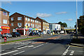
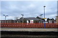
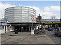
Shops by South Ruislip station
What looks like a small gas holder is the station building. The bridge is too low for double-decker buses.
Image: © Robin Webster
Taken: 6 Oct 2012
0.01 miles
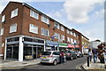
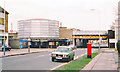
3
Shops, Station Approach, South Ruislip
Image: © Stacey Harris
Taken: 1 Sep 2011
0.02 miles
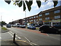
4
Great Central Avenue, South Ruislip
Taken from the junction with Station Approach
Image: © Robin Sones
Taken: 7 Nov 2009
0.02 miles
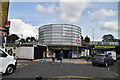
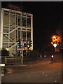
9
South Ruislip station
Served by Central Line underground trains and commuter services from London Marylebone. The tall sign to the left of the road provides a warning to vehicles too high to pass under the railway bridges.
Image: © Peter Whatley
Taken: 2 Apr 2012
0.03 miles
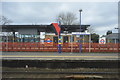
10
South Ruislip Station, exterior 1978
View NW on Station Approach Road, with the bridge carrying the Central Line (West Ruislip branch) nearest and the main lines from Marylebone (ex-GCR) and Paddington (ex-GWR) joining here (just to the right) to form (to the left) the ex-GW&GC Joint main line via High Wycombe and Princes Risborough to Birmingham etc. (GWR) and Leicester, Sheffield etc. (GCR). The station was called 'South Ruislip & Northolt Junction' 1932-1947, 'Northolt Junction' since built 5/1908; the London Underground station was opened 21/11/48. (My BMW 320 is prominent in the foreground). (Cf. Image] and others).
Image: © Ben Brooksbank
Taken: 2 Apr 1978
0.03 miles