IMAGES TAKEN NEAR TO
Lea Crescent, RUISLIP, HA4 6PN
Introduction
This page details the photographs taken nearby to Lea Crescent, HA4 6PN by members of the Geograph project.
The Geograph project started in 2005 with the aim of publishing, organising and preserving representative images for every square kilometre of Great Britain, Ireland and the Isle of Man.

There are currently over 7.5m images from over14,400 individuals and you can help contribute to the project by visiting https://www.geograph.org.uk
Image Map
Images are licensed for reuse under creativecommons.org/licenses/by-sa/2.0
Notes
- Clicking on the map will re-center to the selected point.
- The higher the marker number, the further away the image location is from the centre of the postcode.
Image Listing (36 Images Found)
Images are licensed for reuse under creativecommons.org/licenses/by-sa/2.0
Image
Details
Distance
1
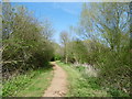
Path alongside the Yeading Brook
The western arm of the Yeading Brook rises near Headstone Manor and converges with the eastern arm of the Yeading Brook(which is also known as The Roxbourne river) in Ruislip on the southern side of Western Avenue. This in turn flows into the River Crane which reaches the Thames at Isleworth. The path here alongside the western arm of the Yeading Brook leads from West End Road near Ruislip Gardens Underground station through to the open fields of Ruislip Gardens open space on the way to Ickenham Marsh. The brook is to the right.
See http://www.londonslostrivers.com/yeading-brook.html
Image: © Marathon
Taken: 20 Apr 2016
0.02 miles
2
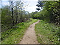
Path alongside the Yeading Brook
The western arm of the Yeading Brook rises near Headstone Manor and converges with the eastern arm of the Yeading Brook(which is also known as The Roxbourne river) in Ruislip on the southern side of Western Avenue. This in turn flows into the River Crane which reaches the Thames at Isleworth. The path here alongside the western arm of the Yeading Brook leads from West End Road near Ruislip Gardens Underground station through to the open fields of Ruislip Gardens open space on the way to Ickenham Marsh. The brook is to the left.
See http://www.londonslostrivers.com/yeading-brook.html
Image: © Marathon
Taken: 20 Apr 2016
0.03 miles


5
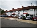
Ruislip Gardens - Clyfford Road
Terrace housing estate north of RAF Northolt.
Wikipedia : https://en.wikipedia.org/wiki/RAF_Northolt
Official site : https://www.raf.mod.uk/our-organisation/stations/raf-northolt/
Image: © James Emmans
Taken: 4 Aug 2019
0.08 miles

8
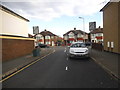
Trevor Crescent at the junction of Bedford Road
Image: © David Howard
Taken: 30 Apr 2015
0.12 miles
9

Alleyway off Trevor Crescent, Ruislip Gardens
I called the cat over but he wasn't interested
Image: © David Howard
Taken: 30 Apr 2015
0.12 miles
10
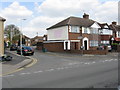
A touch of colour
There just has to be a good story behind the patch of pink on this house at the corner of Bedford Road and Trevor Crescent.
Image: © Peter Whatley
Taken: 2 Apr 2012
0.12 miles