IMAGES TAKEN NEAR TO
Stafford Road, RUISLIP, HA4 6PF
Introduction
This page details the photographs taken nearby to Stafford Road, HA4 6PF by members of the Geograph project.
The Geograph project started in 2005 with the aim of publishing, organising and preserving representative images for every square kilometre of Great Britain, Ireland and the Isle of Man.

There are currently over 7.5m images from over14,400 individuals and you can help contribute to the project by visiting https://www.geograph.org.uk
Image Map
Images are licensed for reuse under creativecommons.org/licenses/by-sa/2.0
Notes
- Clicking on the map will re-center to the selected point.
- The higher the marker number, the further away the image location is from the centre of the postcode.
Image Listing (69 Images Found)
Images are licensed for reuse under creativecommons.org/licenses/by-sa/2.0
Image
Details
Distance
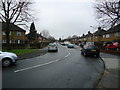
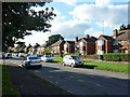
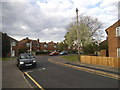
2
Houses on Stafford Road, Ruislip Gardens
Image: © David Howard
Taken: 30 Apr 2015
0.03 miles
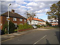
3
Trevor Crescent at the corner of Stafford Road
Image: © David Howard
Taken: 30 Apr 2015
0.03 miles
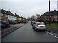
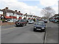
5
Houses on Stafford Road, Ruislip Gardens
On an estate wedged between the railway and RAF Northolt.
Image: © Robin Webster
Taken: 31 Aug 2014
0.06 miles
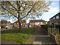
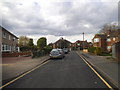
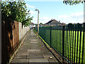
6
Path from Trevor Crescent to Bromley Crescent
Image: © David Howard
Taken: 30 Apr 2015
0.08 miles
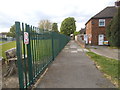
10
Parallel lines
On and by the footpath from Bromley Crescent to Trevor Crescent, Ruislip Gardens.
Image: © Robin Webster
Taken: 31 Aug 2014
0.08 miles