IMAGES TAKEN NEAR TO
The Point, RUISLIP, HA4 6LT
Introduction
This page details the photographs taken nearby to The Point, HA4 6LT by members of the Geograph project.
The Geograph project started in 2005 with the aim of publishing, organising and preserving representative images for every square kilometre of Great Britain, Ireland and the Isle of Man.

There are currently over 7.5m images from over14,400 individuals and you can help contribute to the project by visiting https://www.geograph.org.uk
Image Map
Images are licensed for reuse under creativecommons.org/licenses/by-sa/2.0
Notes
- Clicking on the map will re-center to the selected point.
- The higher the marker number, the further away the image location is from the centre of the postcode.
Image Listing (89 Images Found)
Images are licensed for reuse under creativecommons.org/licenses/by-sa/2.0
Image
Details
Distance
1
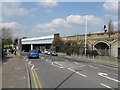
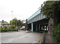
West End Road bridges, Ruislip Gardens
Massive skew bridges with central pillars carry both London Underground and main line railway tracks.
Image: © Peter Whatley
Taken: 2 Apr 2012
0.01 miles
2
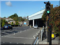
Railway bridge over West End Road
By Ruislip Gardens station on the Central Line, it has a clearance of 4.7 m, 15'-9", so double-deckers can get under it.
Image: © Robin Webster
Taken: 6 Oct 2012
0.02 miles
4
Tulips at Ruislip Gardens
These tulips are at the start of the path alongside the Yeading Brook from West End Road - see http://www.geograph.org.uk/photo/4916467 Beyond is the bridge carrying the Central line and Chiltern Railway tracks across West End Road - see http://www.geograph.org.uk/photo/4916455 for more information about the railway.
Image: © Marathon
Taken: 20 Apr 2016
0.02 miles
5
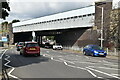
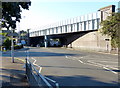
Ruislip Gardens: Skew railway bridge over the A4180 West End Road
The Great Western and Great Central Joint Railway had built this skew bridge over West End Road by 1906 when the line opened. At that time the whole area was just open fields with no buildings and there were therefore no constraints on the new railway route which the railway engineers wanted to keep as straight as possible. The two routes, road and rail, therefore converge with one another at an angle that is no more than 30º. In fact there are two separate bridges, parallel to one another but only about a metre apart.
This is the southern side of the bridge. For a view of the northern side please see Image
The Underground Central Line began services on the railway across the bridge in 1948.
Image: © Nigel Cox
Taken: 16 May 2010
0.02 miles
6
Railway bridge across the A4180 West End Road
Image: © Mat Fascione
Taken: 21 Aug 2015
0.02 miles
7
Path by Yeading Brook
West End Road and Ruislip Gardens station are ahead, with the brook on the right. To continue further upstream, it is necessary to take the road under the railway bridge.
Image: © Robin Webster
Taken: 6 Oct 2012
0.04 miles
8
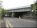
Ruislip Manor: Skew railway bridge over the A4180 West End Road
The Great Western and Great Central Joint Railway had built this skew bridge over West End Road by 1906 when the line opened. At that time the whole area was just open fields with no buildings and there were therefore no constraints on the new railway route which the railway engineers wanted to keep as straight as possible. The two routes, road and rail, therefore converge with one another at an angle that is no more than 30º. In fact there are two separate bridges, parallel to one another but only about a metre apart.
This is the northern side of the bridge. For a view of the southern side please see Image
The Underground Central Line began services on the railway across the bridge in 1948.
Image: © Nigel Cox
Taken: 16 May 2010
0.04 miles

10
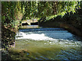
Weir on Yeading Brook
The two span bridge beyond carries West End Road, A4180.
Image: © Robin Webster
Taken: 6 Oct 2012
0.04 miles