IMAGES TAKEN NEAR TO
West End Road, RUISLIP, HA4 6JB
Introduction
This page details the photographs taken nearby to West End Road, HA4 6JB by members of the Geograph project.
The Geograph project started in 2005 with the aim of publishing, organising and preserving representative images for every square kilometre of Great Britain, Ireland and the Isle of Man.

There are currently over 7.5m images from over14,400 individuals and you can help contribute to the project by visiting https://www.geograph.org.uk
Image Map
Images are licensed for reuse under creativecommons.org/licenses/by-sa/2.0
Notes
- Clicking on the map will re-center to the selected point.
- The higher the marker number, the further away the image location is from the centre of the postcode.
Image Listing (85 Images Found)
Images are licensed for reuse under creativecommons.org/licenses/by-sa/2.0
Image
Details
Distance
1
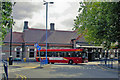
Ruislip station, Metropolitan/Piccadilly Line, 2009
View northward of Up side. Cf. Image
Image: © Ben Brooksbank
Taken: 18 Aug 2009
0.02 miles
2
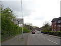
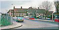
West End Road, Ruislip (A4180)
Looking south west.
Image: © JThomas
Taken: 13 Apr 2019
0.03 miles
3
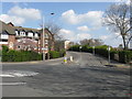
Ruislip - West End Road
Taken from the junction with Wood Lane.
Image: © Peter Whatley
Taken: 2 Apr 2012
0.04 miles
4
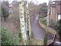
Path alongside Ruislip station
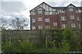
Going from West End Road here to Eversley Crescent, the Barn hotel can be seen on the right.
Image: © David Howard
Taken: 16 Jan 2009
0.05 miles

8
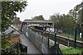
Looking west from Ruislip Underground Station
Taken from the station footbridge
Image: © Robin Sones
Taken: 15 Aug 2014
0.06 miles
9
Ruislip Station, exterior 1978
View northward to the Down side: to right, ex-Metropolitan Railway (now LUL Metropolitan Line) London Baker Street via Harrow-on-the-Hill, also Piccadilly Line Cockfosters via Piccadilly Circus and Acton Town - (to left) Uxbridge.
Image: © Ben Brooksbank
Taken: 2 Apr 1978
0.07 miles
10

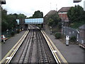
Metropolitan and Piccadilly Lines in Ruislip
The Metropolitan Railway completed their line to Uxbridge in 1904. Later, in 1910, the District Line made a connection to the Metropolitan Railway at Rayners Lane enabling them to run trains to Uxbridge too. Finally in 1933 the Piccadilly Line replaced the District Line, so both Lines use the same track.
This view was taken from the Wood Lane bridge.
The building beyond the tracks is the Ruislip Waitrose.
Image: © Nigel Cox
Taken: 16 May 2010
0.07 miles