IMAGES TAKEN NEAR TO
Crossway, RUISLIP, HA4 0SD
Introduction
This page details the photographs taken nearby to Crossway, HA4 0SD by members of the Geograph project.
The Geograph project started in 2005 with the aim of publishing, organising and preserving representative images for every square kilometre of Great Britain, Ireland and the Isle of Man.

There are currently over 7.5m images from over14,400 individuals and you can help contribute to the project by visiting https://www.geograph.org.uk
Image Map
Images are licensed for reuse under creativecommons.org/licenses/by-sa/2.0
Notes
- Clicking on the map will re-center to the selected point.
- The higher the marker number, the further away the image location is from the centre of the postcode.
Image Listing (28 Images Found)
Images are licensed for reuse under creativecommons.org/licenses/by-sa/2.0
Image
Details
Distance
1
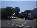
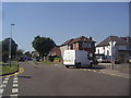
Angus Drive at the junction with The Fairway
Image: © David Howard
Taken: 24 Jul 2012
0.04 miles
2
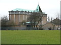
St Mary's Church, South Ruislip
Designed by the architect Laurence King who 'had a considerable reputation for planning places of worship suited to Anglican catholic spirituality'. Work began in October 1957 and the church opened for worship on May 2nd 1959.
Image: © Christine Johnstone
Taken: 8 Mar 2016
0.12 miles
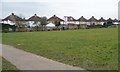
3
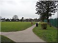
Recreation ground between Long Drive and The Fairway
A large triangle of grass with a playground and a perimeter path.
Image: © Christine Johnstone
Taken: 8 Mar 2016
0.12 miles
5
Queens Walk at the junction of The Fairway, Ruislip
The industrialisation of Middlesex took place around the 1930s, as the houses were all laid out for many miles on fields around the Metropolitan and Central lines. The great majority of them between here and Edgware all look very similar.
Image: © David Howard
Taken: 24 Jul 2012
0.13 miles
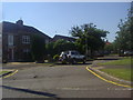
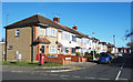
6
Houses backing onto a recreation ground, South Ruislip
They are on the north side of Long Drive.
Image: © Christine Johnstone
Taken: 8 Mar 2016
0.16 miles
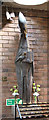
7
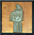
St Gregory the Great, South Ruislip - Station of the Cross
Image: © John Salmon
Taken: 25 Apr 2015
0.17 miles
8
Exmouth Road crosses Barnstaple Road
You go up Bideford Road onto Exmouth Road, past Appledore Drive, cross Barnstaple Road and then left after Shaldon Drive onto Torcross Road.
I think the street namer went to Devon for his holidays that year.
Image: © Des Blenkinsopp
Taken: 27 Oct 2017
0.18 miles
9
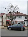
Mistletoe growing in Long Drive, South Ruislip
Rather surprising, but definitely mistletoe.
Image: © Christine Johnstone
Taken: 8 Mar 2016
0.18 miles
10
St Gregory the Great, South Ruislip - Statue
Image: © John Salmon
Taken: 25 Apr 2015
0.18 miles