IMAGES TAKEN NEAR TO
Queens Walk, RUISLIP, HA4 0NP
Introduction
This page details the photographs taken nearby to Queens Walk, HA4 0NP by members of the Geograph project.
The Geograph project started in 2005 with the aim of publishing, organising and preserving representative images for every square kilometre of Great Britain, Ireland and the Isle of Man.

There are currently over 7.5m images from over14,400 individuals and you can help contribute to the project by visiting https://www.geograph.org.uk
Image Map
Images are licensed for reuse under creativecommons.org/licenses/by-sa/2.0
Notes
- Clicking on the map will re-center to the selected point.
- The higher the marker number, the further away the image location is from the centre of the postcode.
Image Listing (23 Images Found)
Images are licensed for reuse under creativecommons.org/licenses/by-sa/2.0
Image
Details
Distance
1
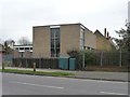
St Andrew's Lutheran Church
At the junction of Whitby Road and Queens Walk. Their website offers information in Latvian as well as English.
Image: © Christine Johnstone
Taken: 8 Mar 2016
0.02 miles
2
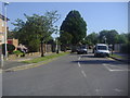
Queens Walk at the junction of Whitby Road
Image: © David Howard
Taken: 24 Jul 2012
0.02 miles
3
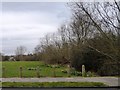
Open space with daffodils, west of Queens Walk
Following the course of Yeading Brook.
Image: © Christine Johnstone
Taken: 8 Mar 2016
0.04 miles
4
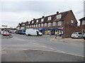
Whitby Parade, Whitby Road
At least nine businesses, including shops, a betting shop and a restaurant.
Image: © Christine Johnstone
Taken: 8 Mar 2016
0.04 miles
5
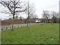
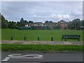
Open space on the east side of Queens Walk
Short posts all round the perimeter prevent vehicle access.
Image: © Christine Johnstone
Taken: 8 Mar 2016
0.05 miles
6
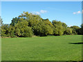
Green space along the Yeading Brook
A corridor of green through suburbia.
Image: © Robin Webster
Taken: 6 Oct 2012
0.06 miles
7
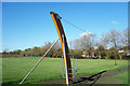
Zip Wire in the Park
A small area of open space beside the Yeading Brook which is behind the trees.
Image: © Des Blenkinsopp
Taken: 27 Oct 2017
0.07 miles
8
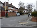
Torcross Road, east of the junction with Queens Walk
Running parallel to, and south of, Yeading Brook.
Image: © Christine Johnstone
Taken: 8 Mar 2016
0.08 miles
10
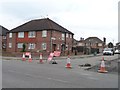
Collins Drive, closed for resurfacing
On the north side of Whitby Road.
Image: © Christine Johnstone
Taken: 8 Mar 2016
0.10 miles