IMAGES TAKEN NEAR TO
Brackenbridge Drive, RUISLIP, HA4 0NF
Introduction
This page details the photographs taken nearby to Brackenbridge Drive, HA4 0NF by members of the Geograph project.
The Geograph project started in 2005 with the aim of publishing, organising and preserving representative images for every square kilometre of Great Britain, Ireland and the Isle of Man.

There are currently over 7.5m images from over14,400 individuals and you can help contribute to the project by visiting https://www.geograph.org.uk
Image Map
Images are licensed for reuse under creativecommons.org/licenses/by-sa/2.0
Notes
- Clicking on the map will re-center to the selected point.
- The higher the marker number, the further away the image location is from the centre of the postcode.
Image Listing (6 Images Found)
Images are licensed for reuse under creativecommons.org/licenses/by-sa/2.0
Image
Details
Distance
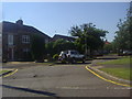
1
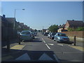
Queens Walk at the junction of The Fairway, Ruislip
The industrialisation of Middlesex took place around the 1930s, as the houses were all laid out for many miles on fields around the Metropolitan and Central lines. The great majority of them between here and Edgware all look very similar.
Image: © David Howard
Taken: 24 Jul 2012
0.18 miles
3
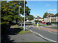
Pedestrian crossing, Field End Road
A Zebra crossing with Belisha beacons, to use terms perhaps less popular than they used to be.
Image: © Robin Webster
Taken: 6 Oct 2012
0.21 miles
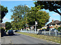
4
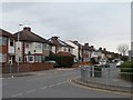
Houses on the north side of Long Drive, South Ruislip
Just east of the junction with Queens Walk.
Image: © Christine Johnstone
Taken: 8 Mar 2016
0.22 miles
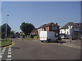
6
Long Drive northbound bus stop
On Field End Lane, served by route 282 from Ealing Hospital to Mount Vernon Hospital.
Image: © Robin Webster
Taken: 6 Oct 2012
0.24 miles