IMAGES TAKEN NEAR TO
Queens Walk, RUISLIP, HA4 0LP
Introduction
This page details the photographs taken nearby to Queens Walk, HA4 0LP by members of the Geograph project.
The Geograph project started in 2005 with the aim of publishing, organising and preserving representative images for every square kilometre of Great Britain, Ireland and the Isle of Man.

There are currently over 7.5m images from over14,400 individuals and you can help contribute to the project by visiting https://www.geograph.org.uk
Image Map
Images are licensed for reuse under creativecommons.org/licenses/by-sa/2.0
Notes
- Clicking on the map will re-center to the selected point.
- The higher the marker number, the further away the image location is from the centre of the postcode.
Image Listing (31 Images Found)
Images are licensed for reuse under creativecommons.org/licenses/by-sa/2.0
Image
Details
Distance
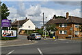
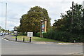
2
Housing on the south side of Jubilee Drive
At the junction with Queen's Walk.
Image: © Christine Johnstone
Taken: 8 Mar 2016
0.05 miles
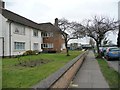
6
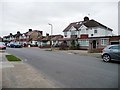
Housing on the north side of Jubilee Drive
Part of South Ruislip's Victoria Park estate.
Image: © Christine Johnstone
Taken: 8 Mar 2016
0.11 miles
9
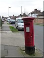
George the Sixth postbox, Jubilee Drive, South Ruislip
On the south side of the road, and standing at a bit of a tilt.
Image: © Christine Johnstone
Taken: 8 Mar 2016
0.15 miles
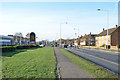
10
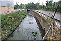
The Roxbourne, South Ruislip
Viewed looking north and upstream along Civic Way towards the culvert that runs under Victoria Road. The Roxbourne shortly becomes the eastern arm of Yeading Brook.
Image: © Nigel Cox
Taken: 27 Jul 2005
0.17 miles