IMAGES TAKEN NEAR TO
Victoria Road, RUISLIP, HA4 0EQ
Introduction
This page details the photographs taken nearby to Victoria Road, HA4 0EQ by members of the Geograph project.
The Geograph project started in 2005 with the aim of publishing, organising and preserving representative images for every square kilometre of Great Britain, Ireland and the Isle of Man.

There are currently over 7.5m images from over14,400 individuals and you can help contribute to the project by visiting https://www.geograph.org.uk
Image Map
Images are licensed for reuse under creativecommons.org/licenses/by-sa/2.0
Notes
- Clicking on the map will re-center to the selected point.
- The higher the marker number, the further away the image location is from the centre of the postcode.
Image Listing (123 Images Found)
Images are licensed for reuse under creativecommons.org/licenses/by-sa/2.0
Image
Details
Distance
2
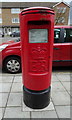
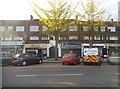
Elizabeth II postbox on Victoria Road, Ruislip
Outside the Post Office.
Postbox No. HA4 512.
Image: © JThomas
Taken: 13 Apr 2019
0.04 miles
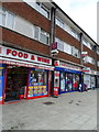
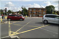
5
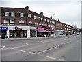
Parade of shops, Victoria Road, South Ruislip
With two-storey flats above.
Image: © Christine Johnstone
Taken: 8 Mar 2016
0.07 miles
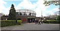
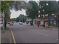
6
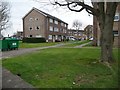
Flats on the north side of Long Drive
At the junction with Victoria Road.
Image: © Christine Johnstone
Taken: 8 Mar 2016
0.07 miles