IMAGES TAKEN NEAR TO
Dartmouth Road, RUISLIP, HA4 0DB
Introduction
This page details the photographs taken nearby to Dartmouth Road, HA4 0DB by members of the Geograph project.
The Geograph project started in 2005 with the aim of publishing, organising and preserving representative images for every square kilometre of Great Britain, Ireland and the Isle of Man.

There are currently over 7.5m images from over14,400 individuals and you can help contribute to the project by visiting https://www.geograph.org.uk
Image Map
Images are licensed for reuse under creativecommons.org/licenses/by-sa/2.0
Notes
- Clicking on the map will re-center to the selected point.
- The higher the marker number, the further away the image location is from the centre of the postcode.
Image Listing (69 Images Found)
Images are licensed for reuse under creativecommons.org/licenses/by-sa/2.0
Image
Details
Distance
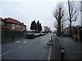
1
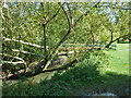
Trees in recreation ground, Ruislip Gardens
Showing signs of autumn, these trees are in an old hedgerow - the recreation ground appears to be a few old fields on low-lying ground by the Yeading Brook.
Image: © Robin Webster
Taken: 6 Oct 2012
0.07 miles
2
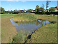
Pond in open space, Ruislip Gardens
An artificial 21st century creation, watered by diverting part of the flow of the ditch running along the back of the houses beyond to give an alternative route to the Yeading Brook behind the camera.
Image: © Robin Webster
Taken: 6 Oct 2012
0.10 miles
3

Ruislip High School
The school, which is on Sidmouth Drive, was opened on 21 March 2007. The school's website is here http://www.ruisliphigh.com/#
Image: © Nigel Cox
Taken: 16 May 2010
0.12 miles
4
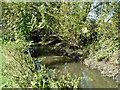
Yeading Brook
Looking downstream with a footbridge just visible.
Image: © Robin Webster
Taken: 6 Oct 2012
0.12 miles

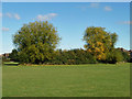
8
Yeading Brook
Looking upstream towards a footbridge.
Image: © Robin Webster
Taken: 6 Oct 2012
0.14 miles
9
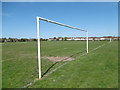
New Pond Farm Fields
New Pond Farm Fields are marked on the map as a recreation ground which frequently signifies a featureless open space and that certainly applies here. The Fields are basically sports pitches and the only vegetation, other than flat grass, is around the western and northern perimeters. See also http://www.geograph.org.uk/photo/4916469
Image: © Marathon
Taken: 20 Apr 2016
0.15 miles