IMAGES TAKEN NEAR TO
Orchard Grove, HARROW, HA3 9QR
Introduction
This page details the photographs taken nearby to Orchard Grove, HA3 9QR by members of the Geograph project.
The Geograph project started in 2005 with the aim of publishing, organising and preserving representative images for every square kilometre of Great Britain, Ireland and the Isle of Man.

There are currently over 7.5m images from over14,400 individuals and you can help contribute to the project by visiting https://www.geograph.org.uk
Image Map
Images are licensed for reuse under creativecommons.org/licenses/by-sa/2.0
Notes
- Clicking on the map will re-center to the selected point.
- The higher the marker number, the further away the image location is from the centre of the postcode.
Image Listing (48 Images Found)
Images are licensed for reuse under creativecommons.org/licenses/by-sa/2.0
Image
Details
Distance
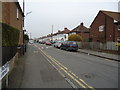
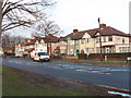
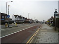
3
Houses on Honeypot Lane
These are at the junction with Elmcroft Gardens
Image: © David Hawgood
Taken: 1 Jan 2006
0.06 miles
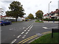
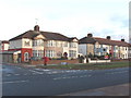
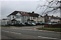
5
Kingbury - Honeypot Lane
Semi-detached houses next to Elmcroft Gardens turning.
Image: © James Emmans
Taken: 17 Nov 2019
0.09 miles
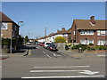
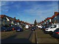
7
Honeypot Lane at the junction of Repton Road
Image: © David Howard
Taken: 6 Feb 2021
0.10 miles