IMAGES TAKEN NEAR TO
D'Arcy Gardens, HARROW, HA3 9JS
Introduction
This page details the photographs taken nearby to D'Arcy Gardens, HA3 9JS by members of the Geograph project.
The Geograph project started in 2005 with the aim of publishing, organising and preserving representative images for every square kilometre of Great Britain, Ireland and the Isle of Man.

There are currently over 7.5m images from over14,400 individuals and you can help contribute to the project by visiting https://www.geograph.org.uk
Image Map
Images are licensed for reuse under creativecommons.org/licenses/by-sa/2.0
Notes
- Clicking on the map will re-center to the selected point.
- The higher the marker number, the further away the image location is from the centre of the postcode.
Image Listing (31 Images Found)
Images are licensed for reuse under creativecommons.org/licenses/by-sa/2.0
Image
Details
Distance
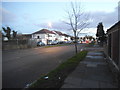
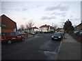
2
Charlton Road at the junction of Kenmore Road
Image: © David Howard
Taken: 23 Dec 2015
0.05 miles
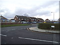
3
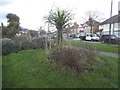
Landscaped grass triangle by Charlton Road
Image: © David Howard
Taken: 23 Dec 2015
0.06 miles
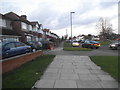
5
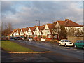
Kenmore Road, Kenton
Looking north, afternoon sun, 2.30 pm on New Year's Day.
Image: © David Hawgood
Taken: 1 Jan 2006
0.08 miles
6
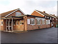
Kenton Evangelical Church, Harrow
In Charlton Road. Opened in 1959.
Image: © David Hawgood
Taken: 1 Jan 2006
0.08 miles
7
Darcy Drive at the junction of Charlton Road
Image: © David Howard
Taken: 23 Dec 2015
0.09 miles
8
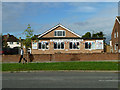
Kenton Evangelical Church
On Charlton Road.
Image: © Robin Webster
Taken: 13 Oct 2012
0.09 miles
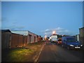
9
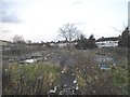
Vacant lot on Kenmore Road, Kenton
This looks like it has been clear a long time, possibly even a bomb site, and will not be developed in the foreseeable future.
Image: © David Howard
Taken: 23 Dec 2015
0.11 miles