IMAGES TAKEN NEAR TO
Kenton Lane, HARROW, HA3 8RJ
Introduction
This page details the photographs taken nearby to Kenton Lane, HA3 8RJ by members of the Geograph project.
The Geograph project started in 2005 with the aim of publishing, organising and preserving representative images for every square kilometre of Great Britain, Ireland and the Isle of Man.

There are currently over 7.5m images from over14,400 individuals and you can help contribute to the project by visiting https://www.geograph.org.uk
Image Map
Images are licensed for reuse under creativecommons.org/licenses/by-sa/2.0
Notes
- Clicking on the map will re-center to the selected point.
- The higher the marker number, the further away the image location is from the centre of the postcode.
Image Listing (29 Images Found)
Images are licensed for reuse under creativecommons.org/licenses/by-sa/2.0
Image
Details
Distance
1
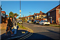
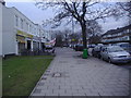
London Borough of Harrow : Grange Avenue
Looking up Grange Avenue off of Kenton Lane.
Image: © Lewis Clarke
Taken: 3 Oct 2018
0.03 miles
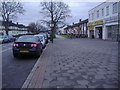
6
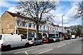
Kenton Lane, shops
This small group of shops on the west side of Kenton Lane is almost opposite the end of Jersey Avenue on the other side.
Image: © Dr Neil Clifton
Taken: 1 Apr 2010
0.12 miles
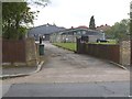
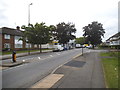
7
London Borough of Harrow : Kenton Lane
Looking along Kenton Lane.
Image: © Lewis Clarke
Taken: 3 Oct 2018
0.13 miles
8
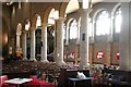
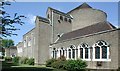
St Anselm, Uppingham Avenue, Belmont - Arcade
Image: © John Salmon
Taken: 6 Jun 2004
0.14 miles
9
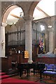
St Anselm, Uppingham Avenue, Belmont - Organ
Image: © John Salmon
Taken: 6 Jun 2004
0.14 miles