IMAGES TAKEN NEAR TO
Belmont Circle, Kenton Lane, HARROW, HA3 8RF
Introduction
This page details the photographs taken nearby to Belmont Circle, Kenton Lane, HA3 8RF by members of the Geograph project.
The Geograph project started in 2005 with the aim of publishing, organising and preserving representative images for every square kilometre of Great Britain, Ireland and the Isle of Man.

There are currently over 7.5m images from over14,400 individuals and you can help contribute to the project by visiting https://www.geograph.org.uk
Image Map
Images are licensed for reuse under creativecommons.org/licenses/by-sa/2.0
Notes
- Clicking on the map will re-center to the selected point.
- The higher the marker number, the further away the image location is from the centre of the postcode.
Image Listing (49 Images Found)
Images are licensed for reuse under creativecommons.org/licenses/by-sa/2.0
Image
Details
Distance
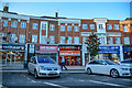
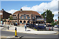
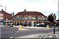
1
Cooper House, Belmont Circle
Belmont Circle is a 1930s development of curving shop terraces with housing above and a large traffic roundabout in the centre. Part of the east side is now a petrol station, but around three quarters is still much as built if you look above the shop fronts.
Image: © Des Blenkinsopp
Taken: 4 Sep 2019
0.01 miles
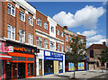
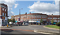
2
London Borough of Harrow : Belmont Circle
Belmont Circle and various shops.
Image: © Lewis Clarke
Taken: 3 Oct 2018
0.01 miles
3
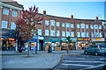
London Borough of Harrow : Belmont Circle
Shops on Belmont Circle.
Image: © Lewis Clarke
Taken: 3 Oct 2018
0.02 miles
4
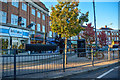
London Borough of Harrow : Belmont Circle
Looking across Belmont Circle.
Image: © Lewis Clarke
Taken: 3 Oct 2018
0.02 miles
5
Funky Brownz Cardamom Restaurant
A 1930s former pub on the north side of Belmont Circle. Now an Indian Restaurant.
A previous name was the Spanish Arch, as seen in this picture Image from 2010.
Image: © Des Blenkinsopp
Taken: 4 Sep 2019
0.03 miles
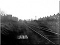
6
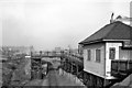
Belmont (Middlesex) Station
View northward, towards Stanmore; Harrow & Wealdstone - Stanmore branch, closed Belmont - Stanmore (Village) 15/9/52 (goods 6/7/64); Belmont station (only opened 12/9/32) was closed 5/10/64 when line from Harrow was closed (completely).
Image: © Ben Brooksbank
Taken: 19 Feb 1961
0.03 miles
7
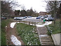
Belmont: Site of former railway station
This is taken from the same location on Kenton Lane as Ben's Image although with the closure of the railway the bridge must have been lowered. Just about the only common feature is the line of houses just visible through the trees to the left. Although the London & North Western Railway opened their line to Stanmore through here in 1890, Belmont's station was not built until 1932. In fact it only lasted for twenty years and three days before being closed to passenger traffic in 1952. The line lingered on with occasional freight trains to Stanmore but closed completely in 1964.
Image: © Nigel Cox
Taken: 1 Dec 2010
0.04 miles
8
Belmont Circle, North Side
A largely intact development from the 1930s consisting of terraced shop-houses around a central roundabout.
Image: © Des Blenkinsopp
Taken: 4 Sep 2019
0.04 miles
9
Belmont: The 'Spanish Arch'
Archetypal large 1930s public house on the east side of Belmont Circus.
Image: © Dr Neil Clifton
Taken: 1 Apr 2010
0.04 miles
10
Belmont, Middlesex
The station seen here from the track to the north. The loop line to the right was removed shortly after the date of this photograph and trains then used the other platform.
Image: © Dr Neil Clifton
Taken: 16 Feb 1957
0.04 miles