IMAGES TAKEN NEAR TO
Christchurch Avenue, HARROW, HA3 8LZ
Introduction
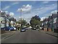
This page details the photographs taken nearby to Christchurch Avenue, HA3 8LZ by members of the Geograph project.
The Geograph project started in 2005 with the aim of publishing, organising and preserving representative images for every square kilometre of Great Britain, Ireland and the Isle of Man.

There are currently over 7.5m images from over14,400 individuals and you can help contribute to the project by visiting https://www.geograph.org.uk
Image Map
Images are licensed for reuse under creativecommons.org/licenses/by-sa/2.0
Notes
- Clicking on the map will re-center to the selected point.
- The higher the marker number, the further away the image location is from the centre of the postcode.
Image Listing (34 Images Found)
Images are licensed for reuse under creativecommons.org/licenses/by-sa/2.0
Image
Details
Distance
10
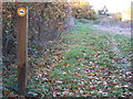
Belmont Trail near Wealdstone
The Belmont Trail is a footpath following the course of a former railway line. The railway ran from Harrow & Wealdstone to Stanmore Village, but closed in 1964.
Image: © Malc McDonald
Taken: 7 Nov 2010
0.15 miles