IMAGES TAKEN NEAR TO
Elmore Close, HARROW, HA3 8FJ
Introduction
This page details the photographs taken nearby to Elmore Close, HA3 8FJ by members of the Geograph project.
The Geograph project started in 2005 with the aim of publishing, organising and preserving representative images for every square kilometre of Great Britain, Ireland and the Isle of Man.

There are currently over 7.5m images from over14,400 individuals and you can help contribute to the project by visiting https://www.geograph.org.uk
Image Map
Images are licensed for reuse under creativecommons.org/licenses/by-sa/2.0
Notes
- Clicking on the map will re-center to the selected point.
- The higher the marker number, the further away the image location is from the centre of the postcode.
Image Listing (43 Images Found)
Images are licensed for reuse under creativecommons.org/licenses/by-sa/2.0
Image
Details
Distance
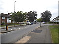
2
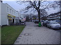
London Borough of Harrow : Grange Avenue
Looking up Grange Avenue off of Kenton Lane.
Image: © Lewis Clarke
Taken: 3 Oct 2018
0.06 miles
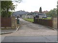
5
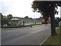
Belmont Community Hall
This is very close to the old station which closed in the late 50s and was on a branch from the line to Watford Junction.
Image: © David Howard
Taken: 29 May 2014
0.14 miles
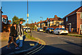
6
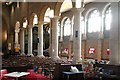
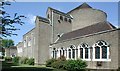
St Anselm, Uppingham Avenue, Belmont - Arcade
Image: © John Salmon
Taken: 6 Jun 2004
0.14 miles
7
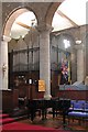
St Anselm, Uppingham Avenue, Belmont - Organ
Image: © John Salmon
Taken: 6 Jun 2004
0.14 miles
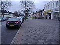
9
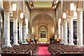
St Anselm, Uppingham Avenue, Belmont - East end
Image: © John Salmon
Taken: 6 Jun 2004
0.15 miles