IMAGES TAKEN NEAR TO
Kenton Road, HARROW, HA3 8AE
Introduction
This page details the photographs taken nearby to Kenton Road, HA3 8AE by members of the Geograph project.
The Geograph project started in 2005 with the aim of publishing, organising and preserving representative images for every square kilometre of Great Britain, Ireland and the Isle of Man.

There are currently over 7.5m images from over14,400 individuals and you can help contribute to the project by visiting https://www.geograph.org.uk
Image Map
Images are licensed for reuse under creativecommons.org/licenses/by-sa/2.0
Notes
- Clicking on the map will re-center to the selected point.
- The higher the marker number, the further away the image location is from the centre of the postcode.
Image Listing (132 Images Found)
Images are licensed for reuse under creativecommons.org/licenses/by-sa/2.0
Image
Details
Distance
1
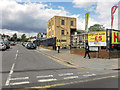
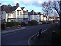
London Borough of Brent : Hawthorne Avenue
Looking along Hawthorne Avenue from Kenton Road.
Image: © Lewis Clarke
Taken: 18 Jul 2019
0.02 miles
2
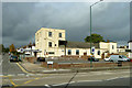
Churchill Hall
The home of Wembley North Conservative Club Ltd.
Image: © Robin Webster
Taken: 13 Oct 2012
0.04 miles
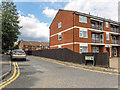
3

Rushout Avenue, Kenton
This road links the north entrance to Northwick Park station with Kenton Road.
Image: © David Kemp
Taken: 8 Apr 2010
0.05 miles
4
London Borough of Brent : Rufford Close
Rufford Close off Kenton Road.
Image: © Lewis Clarke
Taken: 18 Jul 2019
0.08 miles
7
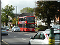
183 bus on Kenton Road
Transdev Scania fleet number SP78 is heading for Golders Green.
Image: © Robin Webster
Taken: 13 Oct 2012
0.10 miles
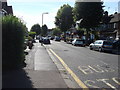
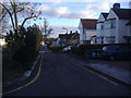
10
Hawthorne Avenue
Looking south towards Kenton Road
Image: © David Howard
Taken: 11 Feb 2010
0.11 miles