IMAGES TAKEN NEAR TO
Stafford Road, HARROW, HA3 6NB
Introduction
This page details the photographs taken nearby to Stafford Road, HA3 6NB by members of the Geograph project.
The Geograph project started in 2005 with the aim of publishing, organising and preserving representative images for every square kilometre of Great Britain, Ireland and the Isle of Man.

There are currently over 7.5m images from over14,400 individuals and you can help contribute to the project by visiting https://www.geograph.org.uk
Image Map
Images are licensed for reuse under creativecommons.org/licenses/by-sa/2.0
Notes
- Clicking on the map will re-center to the selected point.
- The higher the marker number, the further away the image location is from the centre of the postcode.
Image Listing (18 Images Found)
Images are licensed for reuse under creativecommons.org/licenses/by-sa/2.0
Image
Details
Distance
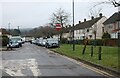
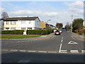
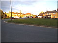
3
Whittlesea Road at the junction of Boxtree Lane
Image: © David Howard
Taken: 27 Jan 2021
0.12 miles
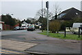
6
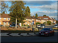
Long Elmes, Harrow Weald
The roundabout is at the junction of Long Elmes and Courtenay Avenue.
Image: © Stephen McKay
Taken: 29 Oct 2018
0.19 miles
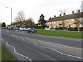
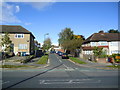
8
Long Elmes by the junction with Courtenay Avenue
Image: © David Howard
Taken: 9 Jan 2014
0.20 miles
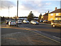
9
Long Elmes at the corner of Courtenay Avenue
Image: © David Howard
Taken: 9 Jan 2014
0.21 miles
10
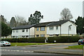
Houses on Courtenay Avenue
The front face of an estate of similar houses, most boarded horizontally in plastic now, but a few still with the style as the second from the right, looking like power station boiler insulation cleading. This might have been the style on all of the houses when new.
Image: © Robin Webster
Taken: 23 Feb 2013
0.21 miles