IMAGES TAKEN NEAR TO
Lavender Gardens, HARROW, HA3 6DD
Introduction
This page details the photographs taken nearby to Lavender Gardens, HA3 6DD by members of the Geograph project.
The Geograph project started in 2005 with the aim of publishing, organising and preserving representative images for every square kilometre of Great Britain, Ireland and the Isle of Man.

There are currently over 7.5m images from over14,400 individuals and you can help contribute to the project by visiting https://www.geograph.org.uk
Image Map
Images are licensed for reuse under creativecommons.org/licenses/by-sa/2.0
Notes
- Clicking on the map will re-center to the selected point.
- The higher the marker number, the further away the image location is from the centre of the postcode.
Image Listing (46 Images Found)
Images are licensed for reuse under creativecommons.org/licenses/by-sa/2.0
Image
Details
Distance
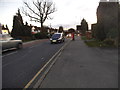
3
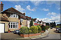
Monro Gardens, Harrow Weald
One of the many residential cul de sacs from the 1930s.
Image: © Des Blenkinsopp
Taken: 2 Oct 2019
0.13 miles
4
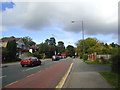
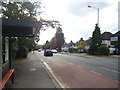
Roundabout on Uxbridge Road, Harrow Weald
At the junction of Brookshill
Image: © David Howard
Taken: 9 Jan 2014
0.14 miles
7
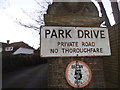
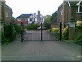
Signs at the entrance to Park Drive, Harrow Weald
Image: © David Howard
Taken: 9 Jan 2014
0.14 miles
8
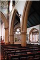
All Saints, Harrow Weald, Middlesex - South arcade
Image: © John Salmon
Taken: 21 Sep 2002
0.15 miles
9
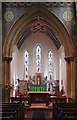
All Saints, Harrow Weald, Middlesex - East end
Image: © John Salmon
Taken: 21 Sep 2002
0.15 miles
10
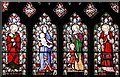
All Saints, Harrow Weald, Middlesex - Window
Image: © John Salmon
Taken: 21 Sep 2002
0.16 miles