IMAGES TAKEN NEAR TO
Barratt Way, HARROW, HA3 5UU
Introduction
This page details the photographs taken nearby to Barratt Way, HA3 5UU by members of the Geograph project.
The Geograph project started in 2005 with the aim of publishing, organising and preserving representative images for every square kilometre of Great Britain, Ireland and the Isle of Man.

There are currently over 7.5m images from over14,400 individuals and you can help contribute to the project by visiting https://www.geograph.org.uk
Image Map
Images are licensed for reuse under creativecommons.org/licenses/by-sa/2.0
Notes
- Clicking on the map will re-center to the selected point.
- The higher the marker number, the further away the image location is from the centre of the postcode.
Image Listing (28 Images Found)
Images are licensed for reuse under creativecommons.org/licenses/by-sa/2.0
Image
Details
Distance
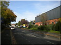
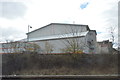
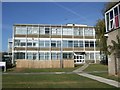
2
Industrial units, Barratt Way, Wealdstone
Image: © N Chadwick
Taken: 19 Dec 2010
0.04 miles
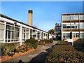
3
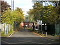
Entrance to Whitefriars School, Wealdstone
Off Tudor Road, with gates firmly closed on a Saturday afternoon.
Image: © Richard Vince
Taken: 29 Oct 2022
0.05 miles
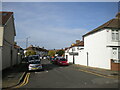
4
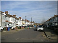
Athelstone Road, Wealdstone
Off Tudor Road.
Image: © Richard Vince
Taken: 29 Oct 2022
0.06 miles
7
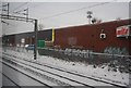
Graffiti on Industrial unit, Barratt Way
Image: © N Chadwick
Taken: 19 Dec 2010
0.09 miles
10
Marthorne Crescent, Wealdstone
Off Athelstone Road.
Image: © Richard Vince
Taken: 29 Oct 2022
0.10 miles