IMAGES TAKEN NEAR TO
Theobald Crescent, HARROW, HA3 5NB
Introduction
This page details the photographs taken nearby to Theobald Crescent, HA3 5NB by members of the Geograph project.
The Geograph project started in 2005 with the aim of publishing, organising and preserving representative images for every square kilometre of Great Britain, Ireland and the Isle of Man.

There are currently over 7.5m images from over14,400 individuals and you can help contribute to the project by visiting https://www.geograph.org.uk
Image Map
Images are licensed for reuse under creativecommons.org/licenses/by-sa/2.0
Notes
- Clicking on the map will re-center to the selected point.
- The higher the marker number, the further away the image location is from the centre of the postcode.
Image Listing (49 Images Found)
Images are licensed for reuse under creativecommons.org/licenses/by-sa/2.0
Image
Details
Distance
1
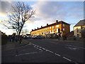
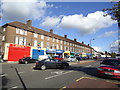
Parade of shops on Long Elmes, Headstone Lane
Image: © David Howard
Taken: 9 Jan 2014
0.06 miles
2
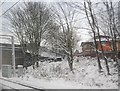
West Coast Main Line near Headstone Lane Station
The station is behind the photographer.
Image: © N Chadwick
Taken: 19 Dec 2010
0.06 miles
3
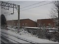
Flats, Augustine Rd, Harrow Weald by the West Coast Main Line
Image: © N Chadwick
Taken: 19 Dec 2010
0.08 miles
4
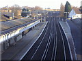
On Headstone Lane Station
Opened in 1913 by the London & North Western Railway, it is now on the London Overground line with services to Euston and Watford. It sees around half a million passengers per year.
The rails between the tracks are just lying there, not part of the electrics.
Image: © Des Blenkinsopp
Taken: 2 Oct 2019
0.08 miles
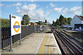
5
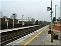
Station platforms, Headstone Lane
Only a station on the DC local lines, now operated as London Overground. The main AC lines pass behind the fence to the left.
Image: © Robin Webster
Taken: 23 Feb 2013
0.08 miles
6
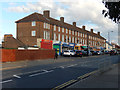
Long Elmes, Harrow Weald
This parade of shops at the western end of Long Elmes is typical of dozens of such blocks to be found across the London suburbs. Originally there might have been traditional grocers, greengrocers and butchers; nowadays food takeaways and convenience stores are more common. See Stacey Harris's view from six years earlier Image; not much appears to have changed although the second unit from the left is now occupied.
Image: © Stephen McKay
Taken: 29 Oct 2018
0.08 miles
8
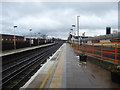
Headstone Lane station
The London & Birmingham Railway opened from Euston to Boxmoor in 1837 and on to Birmingham in 1838. In 1846 it became part of the London & North Western Railway. Headstone Lane station opened on 10th February 1913. Suburban trains were diverted from 15th June 1912 to run over the "New Lines", which had just been built between Euston and Watford Junction. This is the route which was used by Bakerloo services from 16th April 1917 until 24th September 1982 and are used today by London Overground trains.
The fast lines are beyond the station to the left here. The next station in this direction is Harrow & Wealdstone.
Image: © Marathon
Taken: 13 Dec 2017
0.09 miles
10
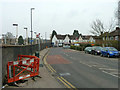
Headstone Lane
The bus stops, for route H19, are Headstone Lane Station. The station is over the wall to the left.
Image: © Robin Webster
Taken: 23 Feb 2013
0.09 miles