IMAGES TAKEN NEAR TO
Waverley Road, HARROW, HA2 9RF
Introduction
This page details the photographs taken nearby to Waverley Road, HA2 9RF by members of the Geograph project.
The Geograph project started in 2005 with the aim of publishing, organising and preserving representative images for every square kilometre of Great Britain, Ireland and the Isle of Man.

There are currently over 7.5m images from over14,400 individuals and you can help contribute to the project by visiting https://www.geograph.org.uk
Image Map
Images are licensed for reuse under creativecommons.org/licenses/by-sa/2.0
Notes
- Clicking on the map will re-center to the selected point.
- The higher the marker number, the further away the image location is from the centre of the postcode.
Image Listing (29 Images Found)
Images are licensed for reuse under creativecommons.org/licenses/by-sa/2.0
Image
Details
Distance
4
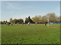
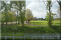
Rayners Lane: Roxbourne Park
"Match Of The Day" in progress.
Image: © Nigel Cox
Taken: 20 Nov 2005
0.14 miles
5
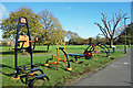
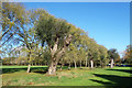
Exercise Machines in Roxbourne Park
A very pleasant local park, with open spaces, leafy walks, sports fields and this kit here for the serious exercisers.
Image: © Des Blenkinsopp
Taken: 27 Oct 2017
0.15 miles