IMAGES TAKEN NEAR TO
Lulworth Gardens, HARROW, HA2 9NW
Introduction
This page details the photographs taken nearby to Lulworth Gardens, HA2 9NW by members of the Geograph project.
The Geograph project started in 2005 with the aim of publishing, organising and preserving representative images for every square kilometre of Great Britain, Ireland and the Isle of Man.

There are currently over 7.5m images from over14,400 individuals and you can help contribute to the project by visiting https://www.geograph.org.uk
Image Map
Images are licensed for reuse under creativecommons.org/licenses/by-sa/2.0
Notes
- Clicking on the map will re-center to the selected point.
- The higher the marker number, the further away the image location is from the centre of the postcode.
Image Listing (17 Images Found)
Images are licensed for reuse under creativecommons.org/licenses/by-sa/2.0
Image
Details
Distance
2
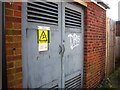
Electricity sub station rear of Dunster Way
Image: © Alex McGregor
Taken: 14 Feb 2013
0.14 miles
3
Houses in blocks of three, Torbay Road
Unusual in most suburbs, but quite common on this estate.
Image: © Christine Johnstone
Taken: 8 Mar 2016
0.17 miles
4
Silver birch on Dunster Way
Looking east from the junction with Torbay Road. Most of the streets in this estate are named after places in Somerset and Devon.
Image: © Christine Johnstone
Taken: 8 Mar 2016
0.18 miles
5
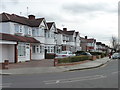
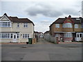
Houses on the east side of Torbay Road
Just south of the junction with Widdecombe Avenue.
Image: © Christine Johnstone
Taken: 8 Mar 2016
0.19 miles
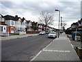
6
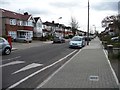
West side pavement, Torbay Road
The amount of dropped kerbing shows how many front gardens are used for car parking.
Image: © Christine Johnstone
Taken: 8 Mar 2016
0.21 miles
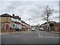
7
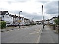
Torbay Road, north of Roxbourne Primary School
The yellow road markings forbid parking near the school entrance.
Image: © Christine Johnstone
Taken: 8 Mar 2016
0.21 miles
8
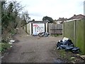
Fly-tipping, west of Torbay Road
One of the many back lanes in this estate. Many are gated and locked, but this one is not, probably because it also provides access to the recreation ground.
Image: © Christine Johnstone
Taken: 8 Mar 2016
0.21 miles
9
Back lane running east from Torbay Road
This estate was built with back lanes behind all the houses. Most, like this one, are gated and locked.
Image: © Christine Johnstone
Taken: 8 Mar 2016
0.22 miles
10
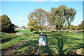
Newton Park (west)
Open space and playing fields beside the Roxbourne. A main road cuts the park into two sections.
Image: © Des Blenkinsopp
Taken: 27 Oct 2017
0.23 miles