IMAGES TAKEN NEAR TO
Walton Avenue, HARROW, HA2 8RB
Introduction
This page details the photographs taken nearby to Walton Avenue, HA2 8RB by members of the Geograph project.
The Geograph project started in 2005 with the aim of publishing, organising and preserving representative images for every square kilometre of Great Britain, Ireland and the Isle of Man.

There are currently over 7.5m images from over14,400 individuals and you can help contribute to the project by visiting https://www.geograph.org.uk
Image Map
Images are licensed for reuse under creativecommons.org/licenses/by-sa/2.0
Notes
- Clicking on the map will re-center to the selected point.
- The higher the marker number, the further away the image location is from the centre of the postcode.
Image Listing (30 Images Found)
Images are licensed for reuse under creativecommons.org/licenses/by-sa/2.0
Image
Details
Distance
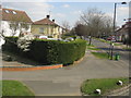
2
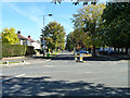
Somervell Road
Looking from its junction with Field End Road.
Image: © Robin Webster
Taken: 6 Oct 2012
0.04 miles
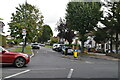
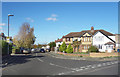
5
Field End Road
View NNW along Field End Road from the railway bridge.
The houses on the right are in Somervell Road.
Image: © David P Howard
Taken: 13 Apr 2014
0.09 miles
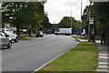
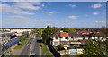
7
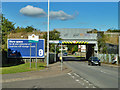
Entering Hillingdon under railway bridges
Only partly true if the map is correct, as the right hand side of the road is Harrow for some way yet. The railway bridges carry the Great Central link out of Marylebone towards the old Great Western line to the north.
Image: © Robin Webster
Taken: 6 Oct 2012
0.11 miles