IMAGES TAKEN NEAR TO
Tregenna Avenue, HARROW, HA2 8QP
Introduction
This page details the photographs taken nearby to Tregenna Avenue, HA2 8QP by members of the Geograph project.
The Geograph project started in 2005 with the aim of publishing, organising and preserving representative images for every square kilometre of Great Britain, Ireland and the Isle of Man.

There are currently over 7.5m images from over14,400 individuals and you can help contribute to the project by visiting https://www.geograph.org.uk
Image Map
Images are licensed for reuse under creativecommons.org/licenses/by-sa/2.0
Notes
- Clicking on the map will re-center to the selected point.
- The higher the marker number, the further away the image location is from the centre of the postcode.
Image Listing (28 Images Found)
Images are licensed for reuse under creativecommons.org/licenses/by-sa/2.0
Image
Details
Distance
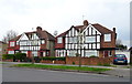
1
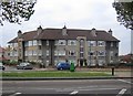
South Harrow: Park Gates flats
These 1930s flats are at the junction of Arundel Drive with Tregenna Avenue. The park in question is Alexandra Park which is on the opposite side of Alexandra Avenue and behind the photographer.
Image: © Nigel Cox
Taken: 24 Oct 2007
0.10 miles
2
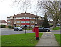
Flats on Alexandra Avenue, Harrow
Showing position of Postbox No. HA2 408.
See Image] for postbox.
Image: © JThomas
Taken: 13 Apr 2019
0.12 miles
3
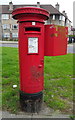
George VI postbox on Alexandra Avenue, Harrow
Postbox No. HA2 408.
See Image] for context.
Image: © JThomas
Taken: 13 Apr 2019
0.12 miles
4
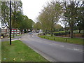
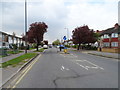
South Harrow: A4090 Alexandra Avenue
Looking in the direction of Rayners Lane with Alexandra Park to the right. Image are just out of sight to the left.
Image: © Nigel Cox
Taken: 24 Oct 2007
0.14 miles
6
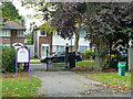
Exit from Alexandra Park to Alexandra Avenue (A4090)
Image: © Robin Webster
Taken: 13 Oct 2012
0.16 miles
8
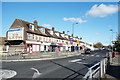
Shops on Eastcote Lane
This may well have been a lane before the suburbs arrived. Some of the area's busiest highways are still called Lanes.
Image: © Des Blenkinsopp
Taken: 27 Oct 2017
0.18 miles
9
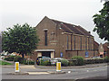
South Harrow Methodist church
The church stands on the corner of Walton Avenue and Carlyon Avenue.
Image: © David Kemp
Taken: 2 Jun 2008
0.19 miles
10
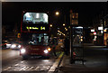
Eastcote Lane
An evening bus on the 114 route collects passengers from the Kings Road stop. The vehicle is a Scania with East Lanc's OmniDekka body and is operated by Transdev.
Image: © Martin Addison
Taken: 3 Jan 2011
0.19 miles