IMAGES TAKEN NEAR TO
Park Lane, HARROW, HA2 8NW
Introduction
This page details the photographs taken nearby to Park Lane, HA2 8NW by members of the Geograph project.
The Geograph project started in 2005 with the aim of publishing, organising and preserving representative images for every square kilometre of Great Britain, Ireland and the Isle of Man.

There are currently over 7.5m images from over14,400 individuals and you can help contribute to the project by visiting https://www.geograph.org.uk
Image Map
Images are licensed for reuse under creativecommons.org/licenses/by-sa/2.0
Notes
- Clicking on the map will re-center to the selected point.
- The higher the marker number, the further away the image location is from the centre of the postcode.
Image Listing (99 Images Found)
Images are licensed for reuse under creativecommons.org/licenses/by-sa/2.0
Image
Details
Distance
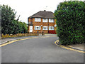
1
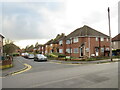
Paddocks Close, South Harrow
Paddocks Close is a short residential cul-de-sac in South Harrow, in the outer suburbs of north west London.
Image: © Malc McDonald
Taken: 6 Jan 2024
0.07 miles
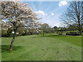
2
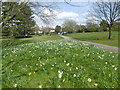
Alexandra Park
Alexandra Park was opened as a public park in 1928, laid out on land conveyed to Harrow-on-the-Hill Urban District Council by the executors of Cllr. A B Champniss. It was formerly part of the Paddocks Pleasure Grounds recreated in 1912 from Grove Farm. Alexandra Park was named after Queen Alexandra, wife of King Edward VIIth, who frequently visited the area.
This is at the northern end of the park, looking towards the exit onto Park Lane.
Image: © Marathon
Taken: 13 Apr 2016
0.09 miles
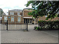
4
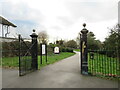
Alexandra Park, South Harrow
An entrance leading into Alexandra Park in South Harrow, in the suburbs of north west London.
Image: © Malc McDonald
Taken: 6 Jan 2024
0.09 miles
5
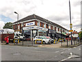
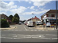
London Borough of Harrow : Park Lane
Looking along Park Lane from Northolt Road.
Image: © Lewis Clarke
Taken: 18 Jul 2019
0.10 miles
6
London Borough of Harrow : Saint Gabriel's Church
A church on Northolt Road.
Image: © Lewis Clarke
Taken: 18 Jul 2019
0.11 miles
7
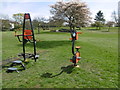
Play equipment in Alexandra Park
Alexandra Park was opened as a public park in 1928, laid out on land conveyed to Harrow-on-the-Hill Urban District Council by the executors of Cllr. A B Champniss. It was formerly part of the Paddocks Pleasure Grounds recreated in 1912 from Grove Farm. Alexandra Park was named after Queen Alexandra, wife of King Edward VIIth, who frequently visited the area.
This is at the northern end of the park, looking towards the exit onto Park Lane.
Image: © Marathon
Taken: 13 Apr 2016
0.11 miles
8
Alexandra Park
Alexandra Park was opened as a public park in 1928, laid out on land conveyed to Harrow-on-the-Hill Urban District Council by the executors of Cllr. A B Champniss. It was formerly part of the Paddocks Pleasure Grounds recreated in 1912 from Grove Farm. Alexandra Park was named after Queen Alexandra, wife of King Edward VIIth, who frequently visited the area.
This is at the northern end of the park, looking towards the exit onto Park Lane.
Image: © Marathon
Taken: 13 Apr 2016
0.11 miles
9
London Borough of Harrow : Northolt Road
Northolt Road in Harrow.
Image: © Lewis Clarke
Taken: 18 Jul 2019
0.11 miles
10
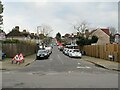
Wood End Avenue, South Harrow
Wood End Avenue is a residential road in South Harrow, in the outer suburbs of north west London.
Image: © Malc McDonald
Taken: 6 Jan 2024
0.12 miles