IMAGES TAKEN NEAR TO
Raglan Terrace, Stroud Gate, HARROW, HA2 8JT
Introduction
This page details the photographs taken nearby to Raglan Terrace, Stroud Gate, HA2 8JT by members of the Geograph project.
The Geograph project started in 2005 with the aim of publishing, organising and preserving representative images for every square kilometre of Great Britain, Ireland and the Isle of Man.

There are currently over 7.5m images from over14,400 individuals and you can help contribute to the project by visiting https://www.geograph.org.uk
Image Map
Images are licensed for reuse under creativecommons.org/licenses/by-sa/2.0
Notes
- Clicking on the map will re-center to the selected point.
- The higher the marker number, the further away the image location is from the centre of the postcode.
Image Listing (112 Images Found)
Images are licensed for reuse under creativecommons.org/licenses/by-sa/2.0
Image
Details
Distance
1
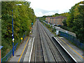
Railway east of Northolt Park
The Great Central Railway route towards Marylebone, passenger services currently provided by Chiltern Railways.
Image: © Robin Webster
Taken: 13 Oct 2012
0.07 miles
3
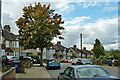
Tree on Westwood Avenue
An area of semi-detached houses.
Image: © Robin Webster
Taken: 13 Oct 2012
0.07 miles
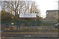
4
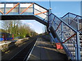
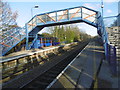
Northolt Park station
On 20th November 1905 the Great Central Railway opened a new route for freight trains between Neasden Junction and Northolt Junction, and on 1st March 1906 passenger services began from High Wycombe to the Great Central's then new terminus at Marylebone. The line was built though open country, yet impressive stations were provided. However, Northolt Park station was not opened until 1926 when it was called South Harrow and Roxeth, and was given its current name in 1929. However, passengers tended to opt for the parallel (now Piccadilly) line, and by 1968 the service was said to be the sparsest in London. Plans were afoot to close it between Neasden and Northolt and direct trains into Paddington, but the line has survived.
There is an hourly service from Northolt Park station. The next station in this direction is Sudbury Hill Harrow.
Image: © Marathon
Taken: 9 Dec 2015
0.07 miles
5
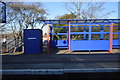
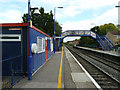
Northolt Park station exterior
The station ticket office and waiting room are housed on its London-bound platform in the not very photogenic blue and red cabin-type building. Northolt Park is on the line from High Wycombe to London Marylebone. Much of this line was not opened until 1906 which made it part of the last mainline railway to reach London before the construction of the Channel Tunnel Rail Link approximately a century later. The station itself was opened in 1926 by the London & North Eastern Railway.
Image: © David Kemp
Taken: 2 Jun 2008
0.08 miles
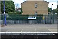
8
Northolt Park station
On the up platform with the cheapskate station booking office, which was closed on a Saturday.
Image: © Robin Webster
Taken: 13 Oct 2012
0.08 miles
9
Northolt Park station
On 20th November 1905 the Great Central Railway opened a new route for freight trains between Neasden Junction and Northolt Junction, and on 1st March 1906 passenger services began from High Wycombe to the Great Central's then new terminus at Marylebone. The line was built though open country, yet impressive stations were provided. However, Northolt Park station was not opened until 1926 when it was called South Harrow and Roxeth, and was given its current name in 1929. However, passengers tended to opt for the parallel (now Piccadilly) line, and by 1968 the service was said to be the sparsest in London. Plans were afoot to close it between Neasden and Northolt and direct trains into Paddington, but the line has survived.
There is an hourly service from Northolt Park station. The next station in this direction is Sudbury Hill Harrow.
Image: © Marathon
Taken: 9 Dec 2015
0.08 miles