IMAGES TAKEN NEAR TO
Barnetts Court, Corbins Lane, HARROW, HA2 8EU
Introduction
This page details the photographs taken nearby to Barnetts Court, Corbins Lane, HA2 8EU by members of the Geograph project.
The Geograph project started in 2005 with the aim of publishing, organising and preserving representative images for every square kilometre of Great Britain, Ireland and the Isle of Man.

There are currently over 7.5m images from over14,400 individuals and you can help contribute to the project by visiting https://www.geograph.org.uk
Image Map
Images are licensed for reuse under creativecommons.org/licenses/by-sa/2.0
Notes
- Clicking on the map will re-center to the selected point.
- The higher the marker number, the further away the image location is from the centre of the postcode.
Image Listing (52 Images Found)
Images are licensed for reuse under creativecommons.org/licenses/by-sa/2.0
Image
Details
Distance
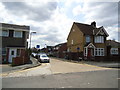
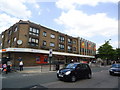
2
Houses on Torrington Drive, South Harrow
Image: © Robin Webster
Taken: 13 Oct 2012
0.03 miles
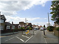
5
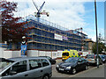
Clearview Court under construction, 2012
Flats by Northolt Road, Harrow, the entrances are round the corner on Corbins Lane.
Image: © Robin Webster
Taken: 13 Oct 2012
0.08 miles
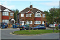
8
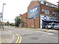
London Borough of Harrow : Torrington Drive
A road off Northolt Road.
Image: © Lewis Clarke
Taken: 18 Jul 2019
0.10 miles
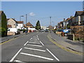
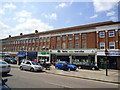
9
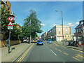
Harrow on The Hill : Northolt Road
Looking along Northolt Road.
Image: © Lewis Clarke
Taken: 12 Sep 2020
0.11 miles
10
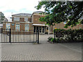
London Borough of Harrow : Saint Gabriel's Church
A church on Northolt Road.
Image: © Lewis Clarke
Taken: 18 Jul 2019
0.13 miles