IMAGES TAKEN NEAR TO
Eastcote Lane, HARROW, HA2 8DB
Introduction
This page details the photographs taken nearby to Eastcote Lane, HA2 8DB by members of the Geograph project.
The Geograph project started in 2005 with the aim of publishing, organising and preserving representative images for every square kilometre of Great Britain, Ireland and the Isle of Man.

There are currently over 7.5m images from over14,400 individuals and you can help contribute to the project by visiting https://www.geograph.org.uk
Image Map
Images are licensed for reuse under creativecommons.org/licenses/by-sa/2.0
Notes
- Clicking on the map will re-center to the selected point.
- The higher the marker number, the further away the image location is from the centre of the postcode.
Image Listing (104 Images Found)
Images are licensed for reuse under creativecommons.org/licenses/by-sa/2.0
Image
Details
Distance
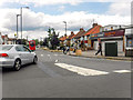
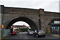
2
Roxeth Viaduct
The District Railway opened its new extension from north of Ealing Common to Park Royal & Twyford Abbey on 23rd June 1903. The line was opened fully to South Harrow on 28th June 1903. A well-built station house was built at the same time next to the up platform. ‘South Harrow’ was a railway renaming of Roxeth, the community on the southern slopes of Harrow Hill. Few passengers were attracted at the start, the fact that trains terminated at South Harrow not helping. District line trains started to run beyond South Harrow on 1st March 1910 to meet the Metropolitan Railway at Rayners Lane and continue on to Uxbridge, but they were only hourly for much of the day, increasing to a 20 minute service the following year. North of South Harrow station, the line crosses the Roxeth Marsh; the viaduct over it between South Harrow and Rayners Lane was an engineering feat of the time. The viaduct is seen here across Sherwood Avenue. Many of the arches have been filled in and immediately east of here, a market operates underneath the arches.
A few streets of small houses appeared close to South Harrow station between 1910 and 1914 so that by 1913 South Harrow was generating a little commuter traffic. As a result, in 1915 a morning business express named ‘The Harrovian’ left South Harrow for the City missing out some intermediate stations.
This new extension was, together with the existing tracks between Ealing Common and Acton Town, the first section of the Underground's surface lines to be electrified and operate electric instead of steam trains. In the early 1930s, Government money was on offer to combat unemployment and using some of this the Piccadilly line was extended to run west of its original terminus at Hammersmith sharing the route with the District line to Ealing Common. This change took place from 4th July 1932. From Ealing Common to South Harrow, the District line was replaced by the Piccadilly line on the same date. Starting in the 1920s but really taking off in the 1930s the surrounding area was covered with housing estates. A new station was opened on 5th July 1935 with its entrance on the main road.
Image: © Marathon
Taken: 9 Dec 2015
0.10 miles
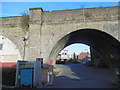
3
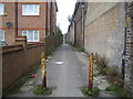
South Harrow: Footpath at the foot of The Viaduct
On the right is the Piccadilly Line viaduct between Rayners Lane and South Harrow Underground stations. The footpath joins Roxeth Green Avenue to Stanley Road.
Image: © Nigel Cox
Taken: 24 Oct 2007
0.10 miles
4
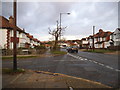
Eastcote Lane looking towards Northolt Road
Image: © David Howard
Taken: 20 Nov 2013
0.10 miles
5
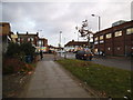
London Borough of Harrow : Eastcote Lane
From Notholt Road looking along Eastcote Lane.
Image: © Lewis Clarke
Taken: 18 Jul 2019
0.10 miles
6
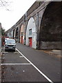
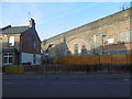
Light industry under railway arches, South Harrow
In London any railway arch is a ready-made site for small business, many of them car repair and similar.
Image: © David Hawgood
Taken: 1 Jan 2006
0.11 miles
7
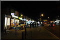
Shops on Northolt Road
Ten to eight at night and the shop keepers are only just starting to put away their wares. Meanwhile, prospective passengers stand around the bus stop waiting for a bus to Harrow. Visible in the distance is the bridge carrying the Piccadilly Line over the road at South Harrow Station.
Image: © Martin Addison
Taken: 11 Jan 2011
0.12 miles
8
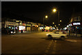
Northolt Road at Night
Viewed from the junction with Eastcote Lane.
Image: © Martin Addison
Taken: 11 Jan 2011
0.12 miles
10
Roxeth Viaduct
The District Railway opened its new extension from north of Ealing Common to Park Royal & Twyford Abbey on 23rd June 1903. The line was opened fully to South Harrow on 28th June 1903. A well-built station house was built at the same time next to the up platform. ‘South Harrow’ was a railway renaming of Roxeth, the community on the southern slopes of Harrow Hill. Few passengers were attracted at the start, the fact that trains terminated at South Harrow not helping. District line trains started to run beyond South Harrow on 1st March 1910 to meet the Metropolitan Railway at Rayners Lane and continue on to Uxbridge, but they were only hourly for much of the day, increasing to a 20 minute service the following year. North of South Harrow station, the line crosses the Roxeth Marsh; the viaduct over it between South Harrow and Rayners Lane was an engineering feat of the time. The viaduct is seen here across Sherwood Avenue. Many of the arches have been filled in and immediately east of here, a market operates underneath the arches.
A few streets of small houses appeared close to South Harrow station between 1910 and 1914 so that by 1913 South Harrow was generating a little commuter traffic. As a result, in 1915 a morning business express named ‘The Harrovian’ left South Harrow for the City missing out some intermediate stations.
This new extension was, together with the existing tracks between Ealing Common and Acton Town, the first section of the Underground's surface lines to be electrified and operate electric instead of steam trains. In the early 1930s, Government money was on offer to combat unemployment and using some of this the Piccadilly line was extended to run west of its original terminus at Hammersmith sharing the route with the District line to Ealing Common. This change took place from 4th July 1932. From Ealing Common to South Harrow, the District line was replaced by the Piccadilly line on the same date. Starting in the 1920s but really taking off in the 1930s the surrounding area was covered with housing estates. A new station was opened on 5th July 1935 with its entrance on the main road.
This view from the car park of a block of flats looks towards Stanley Road on the other side.
Image: © Marathon
Taken: 9 Dec 2015
0.12 miles