IMAGES TAKEN NEAR TO
Sherwood Road, HARROW, HA2 8AW
Introduction
This page details the photographs taken nearby to Sherwood Road, HA2 8AW by members of the Geograph project.
The Geograph project started in 2005 with the aim of publishing, organising and preserving representative images for every square kilometre of Great Britain, Ireland and the Isle of Man.

There are currently over 7.5m images from over14,400 individuals and you can help contribute to the project by visiting https://www.geograph.org.uk
Image Map
Images are licensed for reuse under creativecommons.org/licenses/by-sa/2.0
Notes
- Clicking on the map will re-center to the selected point.
- The higher the marker number, the further away the image location is from the centre of the postcode.
Image Listing (102 Images Found)
Images are licensed for reuse under creativecommons.org/licenses/by-sa/2.0
Image
Details
Distance
1
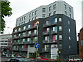
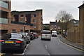
Templar House, South Harrow
These are shared ownership apartments on Northolt Road.
Image: © Danny P Robinson
Taken: 21 May 2006
0.05 miles
2
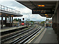
Piccadilly Line northwards from South Harrow
Image: © Robin Webster
Taken: 13 Oct 2012
0.05 miles
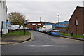
6
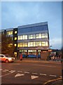
Sherwood House on Northolt Road
Housing a therapy clinic downstairs and solicitors upstairs
Image: © David Howard
Taken: 18 Nov 2014
0.07 miles
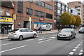
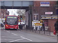
7
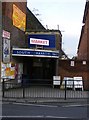
Entrance to South Harrow Market
South Harrow Market is under the railway arches, across the road from the station.
Image: © PAUL FARMER
Taken: 31 Jan 2009
0.07 miles