IMAGES TAKEN NEAR TO
Lincoln Road, HARROW, HA2 7RH
Introduction
This page details the photographs taken nearby to Lincoln Road, HA2 7RH by members of the Geograph project.
The Geograph project started in 2005 with the aim of publishing, organising and preserving representative images for every square kilometre of Great Britain, Ireland and the Isle of Man.

There are currently over 7.5m images from over14,400 individuals and you can help contribute to the project by visiting https://www.geograph.org.uk
Image Map
Images are licensed for reuse under creativecommons.org/licenses/by-sa/2.0
Notes
- Clicking on the map will re-center to the selected point.
- The higher the marker number, the further away the image location is from the centre of the postcode.
Image Listing (46 Images Found)
Images are licensed for reuse under creativecommons.org/licenses/by-sa/2.0
Image
Details
Distance
1
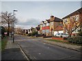
Lincoln Road
Post war semi-detached estate.
Image: © James Emmans
Taken: 20 Nov 2019
0.01 miles


9
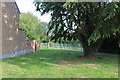
The entrance to Yeading Walk open space
It's not in Yeading but will get you there at the end.
Image: © David Howard
Taken: 21 May 2020
0.07 miles
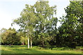
10
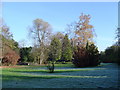
Yeading Brook Open Space, North Harrow
A linear park along Yeading Brook, here between Suffolk Road and Lincoln Road. A bridge over Yeading Brook is visible on the left.
Image: © Nigel Cox
Taken: 20 Nov 2005
0.09 miles